Cañamares geodata
Cañamares (Castille-La Mancha) is a seat of a third-order administrative division; located in Spain in Europe/Madrid (GMT+2) time zone. With population of 623 people, there are 3561 cities with bigger population in this country. Compared to other cities in Spain, 62.9% of cities are located further ↑North; 64.2% of cities are located further ←West and 78.9% of cities have lower elevation than Cañamares. Note1
Administrative division(s):
- Level 1: Castille-La Mancha
- Level 2: Provincia de Cuenca
- Level 3: Cañamares


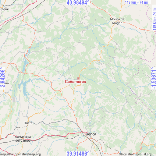
Cañamares GPS coordinates[2]
40° 27' 7.308" North, 2° 14' 23.388" West
| Map corner | latitude | longitude |
|---|---|---|
| Upper-left | 40.98494°, | -2.94296° |
| Center: | 40.45203°, | -2.23983° |
| Lower-right: | 39.91486°, | -1.53671° |
| Map W x H: | 119×119 km | = 73.9×73.9mi |
| max Lat: | 43.74134° ⇑62.9% North |
| Cañamares: | 40.45203° |
| min Lat: | ⇓37.1% South 27.64134° |
| min Long | Cañamares | max Long |
| -18.00367° | -2.23983° | 4.2899° |
| W 64.2%⇐ | ⇒35.8% E |
Elevation
Elevation of Cañamares is 888 m = 2913 ft, and this is 290 m = 951 ft above average elevation for this country.
| Max E: |
1682 m = 5518 ft | 21.1% |
| Cañamares | 888 m 2913 ft | |
| Avg. | 598 m = 1962 ft | |
Min E: |
0 m = 0 ft | 78.9% |
See also: Spain elevation on elevation.city.
Geographical zone
Cañamares is located in North temperate zone (between Tropic of Cancer and the Arctic Circle). Distance of this Northern Tropic circle is 1891.9 km =1175.6 mi to South.| Distance of | km | miles | from Cañamares |
|---|---|---|---|
| North Pole | 5509.2 | 3423.3 | to North |
| Arctic Circle | 2903.3 | 1804 | to North |
| Tropic Cancer | 1891.9 | 1175.6 | to South |
| Equator | 4497.8 | 2794.8 | to South |


Nearby cities:
15 places around Cañamares: (largest is in red/bold)
• Albalate de las Nogueras
10.1 km =6.3 mi,  198°
198°
• Albendea
15.5 km =9.6 mi,  284°
284°
• Alcantud
13.3 km =8.3 mi,  323°
323°
• Arandilla del Arroyo
13.8 km =8.6 mi,  298°
298°
• Arcos de la Sierra
15.9 km =9.9 mi,  137°
137°
• Carrascosa
16.8 km =10.4 mi,  22°
22°
• Castillejo-Sierra
12 km =7.5 mi, 135°
• Cañaveras
16.7 km =10.4 mi,  232°
232°
• Cañizares
8.4 km =5.2 mi,  28°
28°
• Fresneda de la Sierra
10.7 km =6.6 mi,  129°
129°
• Fuertescusa
6 km =3.7 mi,  64°
64°
• La Frontera
5.9 km =3.7 mi,  160°
160°
• Priego
6.3 km =3.9 mi,  267°
267°
• San Pedro Palmiches
14.3 km =8.9 mi,  259°
259°
• Villaconejos de Trabaque
8.8 km =5.5 mi, 229°
Sources, notices
• [Note1] Compared only with cities in Spain existing in our database
• [Src1] Map data: © OpenStreetMap contributors (CC-BY-SA)
• [Src2] Other city data from geonames.org with taken over terms of usage.
• [Src3] Geographical zone / Annual Mean Temperature by Robert A. Rohde @ Wikipedia
