Congosto geodata
Congosto (Castille and León) is a seat of a third-order administrative division; located in Spain in Europe/Madrid (GMT+2) time zone. With population of 1,656 people, there are 2369 cities with bigger population in this country. Compared to other cities in Spain, 89.9% of cities are located further ↓South; 91.4% of cities are located further →East and 52.9% of cities have lower elevation than Congosto. Note1


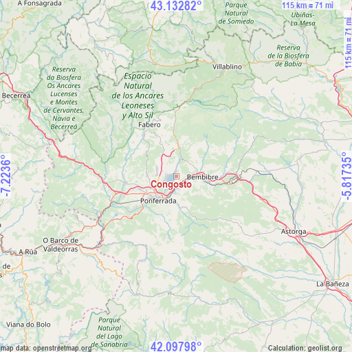
Congosto GPS coordinates[2]
42° 37' 3.18" North, 6° 31' 13.728" West
| Map corner | latitude | longitude |
|---|---|---|
| Upper-left | 43.13282°, | -7.2236° |
| Center: | 42.61755°, | -6.52048° |
| Lower-right: | 42.09798°, | -5.81735° |
| Map W x H: | 115.1×115.1 km | = 71.5×71.5mi |
| max Lat: | 43.74134° ⇑10.1% North |
| Congosto: | 42.61755° |
| min Lat: | ⇓89.9% South 27.64134° |
| min Long | Congosto | max Long |
| -18.00367° | -6.52048° | 4.2899° |
| W 8.6%⇐ | ⇒91.4% E |
Elevation
Elevation of Congosto is 689 m = 2260 ft, and this is 91 m = 299 ft above average elevation for this country.
| Max E: |
1682 m = 5518 ft | 47.1% |
| Congosto | 689 m 2260 ft | |
| Avg. | 598 m = 1962 ft | |
Min E: |
0 m = 0 ft | 52.9% |
See also: Spain elevation on elevation.city.
Geographical zone
Congosto is located in North temperate zone (between Tropic of Cancer and the Arctic Circle). Distance of this Northern Tropic circle is 2132.7 km =1325.2 mi to South.| Distance of | km | miles | from Congosto |
|---|---|---|---|
| North Pole | 5268.4 | 3273.6 | to North |
| Arctic Circle | 2662.5 | 1654.4 | to North |
| Tropic Cancer | 2132.7 | 1325.2 | to South |
| Equator | 4738.6 | 2944.4 | to South |


Nearby cities:
15 places around Congosto: (largest is in red/bold)
• Arganza
13.8 km =8.6 mi,  280°
280°
• Bembibre
8.6 km =5.3 mi,  89°
89°
• Berlanga del Bierzo
14.4 km =8.9 mi,  331°
331°
• Cacabelos
16.7 km =10.4 mi,  263°
263°
• Camponaraya
12.8 km =8 mi,  249°
249°
• Castropodame
6 km =3.7 mi,  134°
134°
• Cubillos del Sil
3.6 km =2.2 mi, 283°
• Folgoso de la Ribera
16.7 km =10.4 mi,  78°
78°
• Molinaseca
8.8 km =5.5 mi,  179°
179°
• Ponferrada
10 km =6.2 mi,  218°
218°
• Priaranza del Bierzo
17.1 km =10.6 mi,  225°
225°
• Sancedo
10.8 km =6.7 mi,  300°
300°
• Toreno
9.1 km =5.7 mi,  4°
4°
• Torre del Bierzo
12.6 km =7.8 mi, 94°
• Vega de Espinareda
16.2 km =10.1 mi,  317°
317°
Sources, notices
• [Note1] Compared only with cities in Spain existing in our database
• [Src1] Map data: © OpenStreetMap contributors (CC-BY-SA)
• [Src2] Other city data from geonames.org with taken over terms of usage.
• [Src3] Geographical zone / Annual Mean Temperature by Robert A. Rohde @ Wikipedia
