Sancedo geodata
Sancedo (Castille and León) is a seat of a third-order administrative division; located in Spain in Europe/Madrid (GMT+2) time zone. In our database, there are 6762 cities with bigger population. Compared to other cities in Spain, 91% of cities are located further ↓South; 92.3% of cities are located further →East and 51.5% of cities have lower elevation than Sancedo. Note1


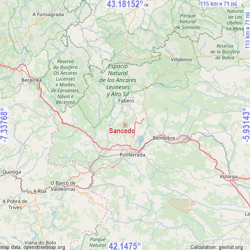
Sancedo GPS coordinates[2]
42° 39' 59.976" North, 6° 38' 4.416" West
| Map corner | latitude | longitude |
|---|---|---|
| Upper-left | 43.18152°, | -7.33768° |
| Center: | 42.66666°, | -6.63456° |
| Lower-right: | 42.1475°, | -5.93143° |
| Map W x H: | 115×115 km | = 71.5×71.5mi |
| max Lat: | 43.74134° ⇑9% North |
| Sancedo: | 42.66666° |
| min Lat: | ⇓91% South 27.64134° |
| min Long | Sancedo | max Long |
| -18.00367° | -6.63456° | 4.2899° |
| W 7.7%⇐ | ⇒92.3% E |
Elevation
Elevation of Sancedo is 675 m = 2215 ft, and this is 77 m = 253 ft above average elevation for this country.
| Max E: |
1682 m = 5518 ft | 48.5% |
| Sancedo | 675 m 2215 ft | |
| Avg. | 598 m = 1962 ft | |
Min E: |
0 m = 0 ft | 51.5% |
See also: Spain elevation on elevation.city.
Geographical zone
Sancedo is located in North temperate zone (between Tropic of Cancer and the Arctic Circle). Distance of this Northern Tropic circle is 2138.2 km =1328.6 mi to South.| Distance of | km | miles | from Sancedo |
|---|---|---|---|
| North Pole | 5263 | 3270.3 | to North |
| Arctic Circle | 2657.1 | 1651 | to North |
| Tropic Cancer | 2138.2 | 1328.6 | to South |
| Equator | 4744.1 | 2947.8 | to South |


Nearby cities:
15 places around Sancedo: (largest is in red/bold)
• Arganza
5.1 km =3.2 mi,  235°
235°
• Berlanga del Bierzo
7.5 km =4.7 mi,  18°
18°
• Cacabelos
10.4 km =6.5 mi,  224°
224°
• Camponaraya
10.2 km =6.3 mi,  195°
195°
• Carracedelo
14.7 km =9.1 mi,  213°
213°
• Castropodame
16.7 km =10.4 mi,  125°
125°
• Congosto
10.8 km =6.7 mi,  120°
120°
• Cubillos del Sil
7.4 km =4.6 mi, 128°
• Fabero
11.3 km =7 mi,  3°
3°
• Molinaseca
17.1 km =10.6 mi,  146°
146°
• Ponferrada
13.7 km =8.5 mi,  166°
166°
• Toreno
10.6 km =6.6 mi,  69°
69°
• Vega de Espinareda
6.7 km =4.2 mi,  346°
346°
• Villadecanes
14.1 km =8.8 mi,  226°
226°
• Villafranca del Bierzo
15.9 km =9.9 mi, 244°
Sources, notices
• [Note1] Compared only with cities in Spain existing in our database
• [Src1] Map data: © OpenStreetMap contributors (CC-BY-SA)
• [Src2] Other city data from geonames.org with taken over terms of usage.
• [Src3] Geographical zone / Annual Mean Temperature by Robert A. Rohde @ Wikipedia
