Molinaseca geodata
Molinaseca (Castille and León) is a seat of a third-order administrative division; located in Spain in Europe/Madrid (GMT+2) time zone. With population of 735 people, there are 3336 cities with bigger population in this country. Compared to other cities in Spain, 88% of cities are located further ↓South; 91.3% of cities are located further →East and 56% of cities have higher elevation than Molinaseca. Note1
Administrative division(s):
- Level 1: Castille and León
- Level 2: Provincia de León
- Level 3: Molinaseca


Molinaseca GPS coordinates[2]
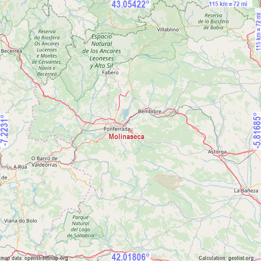
42° 32' 17.844" North, 6° 31' 11.892" West
| Map corner | latitude | longitude |
|---|---|---|
| Upper-left | 43.05422°, | -7.2231° |
| Center: | 42.53829°, | -6.51997° |
| Lower-right: | 42.01806°, | -5.81685° |
| Map W x H: | 115.2×115.2 km | = 71.6×71.6mi |
| max Lat: | 43.74134° ⇑12% North |
| Molinaseca: | 42.53829° |
| min Lat: | ⇓88% South 27.64134° |
| min Long | Molinaseca | max Long |
| -18.00367° | -6.51997° | 4.2899° |
| W 8.7%⇐ | ⇒91.3% E |
Elevation
Elevation of Molinaseca is 582 m = 1909 ft, and this is 16 m = 52 ft below average elevation for this country.
| Max E: |
1682 m = 5518 ft | 56% |
| Avg. | 598 m = 1962 ft | |
| Molinaseca | 582 m = 1909 ft | |
Min E: |
0 m = 0 ft | 44% |
See also: Spain elevation on elevation.city.
Geographical zone
Molinaseca is located in North temperate zone (between Tropic of Cancer and the Arctic Circle). Distance of this Northern Tropic circle is 2123.9 km =1319.7 mi to South.| Distance of | km | miles | from Molinaseca |
|---|---|---|---|
| North Pole | 5277.2 | 3279.1 | to North |
| Arctic Circle | 2671.4 | 1659.9 | to North |
| Tropic Cancer | 2123.9 | 1319.7 | to South |
| Equator | 4729.8 | 2939 | to South |


Nearby cities:
15 places around Molinaseca: (largest is in red/bold)
• Arganza
17.8 km =11.1 mi,  309°
309°
• Bembibre
12.3 km =7.6 mi,  44°
44°
• Borrenes
17.5 km =10.9 mi,  252°
252°
• Cacabelos
18 km =11.2 mi,  292°
292°
• Camponaraya
12.8 km =8 mi, 290°
• Carracedelo
17.6 km =10.9 mi,  276°
276°
• Castropodame
6.2 km =3.9 mi, 42°
• Congosto
8.8 km =5.5 mi,  359°
359°
• Cubillos del Sil
10.3 km =6.4 mi,  339°
339°
• Ponferrada
6.3 km =3.9 mi, 278°
• Priaranza del Bierzo
12.7 km =7.9 mi,  255°
255°
• Sancedo
17.1 km =10.6 mi,  326°
326°
• Toreno
17.9 km =11.1 mi,  1°
1°
• Torre del Bierzo
14.7 km =9.1 mi,  58°
58°
• Villadecanes
20.2 km =12.6 mi, 283°
Sources, notices
• [Note1] Compared only with cities in Spain existing in our database
• [Src1] Map data: © OpenStreetMap contributors (CC-BY-SA)
• [Src2] Other city data from geonames.org with taken over terms of usage.
• [Src3] Geographical zone / Annual Mean Temperature by Robert A. Rohde @ Wikipedia
