Camós geodata
Camós (Catalonia) is a seat of a third-order administrative division; located in Spain in Europe/Madrid (GMT+2) time zone. With population of 660 people, there are 3484 cities with bigger population in this country. Compared to other cities in Spain, 76.2% of cities are located further ↓South; 97.5% of cities are located further ←West and 80.1% of cities have higher elevation than Camós. Note1


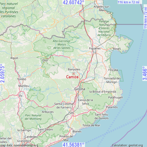
Camós GPS coordinates[2]
42° 5' 15.936" North, 2° 45' 46.368" East
| Map corner | latitude | longitude |
|---|---|---|
| Upper-left | 42.60742°, | 2.05975° |
| Center: | 42.08776°, | 2.76288° |
| Lower-right: | 41.56381°, | 3.466° |
| Map W x H: | 116×116 km | = 72.1×72.1mi |
| max Lat: | 43.74134° ⇑23.8% North |
| Camós: | 42.08776° |
| min Lat: | ⇓76.2% South 27.64134° |
| min Long | Camós | max Long |
| -18.00367° | 2.76288° | 4.2899° |
| W 97.5%⇐ | ⇒2.5% E |
Elevation
Elevation of Camós is 218 m = 715 ft, and this is 380 m = 1247 ft below average elevation for this country.
| Max E: |
1682 m = 5518 ft | 80.1% |
| Avg. | 598 m = 1962 ft | |
| Camós | 218 m = 715 ft | |
Min E: |
0 m = 0 ft | 19.9% |
See also: Spain elevation on elevation.city.
Geographical zone
Camós is located in North temperate zone (between Tropic of Cancer and the Arctic Circle). Distance of this Northern Tropic circle is 2073.8 km =1288.6 mi to South.| Distance of | km | miles | from Camós |
|---|---|---|---|
| North Pole | 5327.3 | 3310.2 | to North |
| Arctic Circle | 2721.5 | 1691.1 | to North |
| Tropic Cancer | 2073.8 | 1288.6 | to South |
| Equator | 4679.7 | 2907.8 | to South |


Nearby cities:
15 places around Camós: (largest is in red/bold)
• Banyoles
3.2 km =2 mi,  5°
5°
• Celrà
11.6 km =7.2 mi,  121°
121°
• Cervià de Ter
12.2 km =7.6 mi,  101°
101°
• Cornellà del Terri
4.5 km =2.8 mi, 96°
• Crespià
11.1 km =6.9 mi,  16°
16°
• Esponellà
9.3 km =5.8 mi, 19°
• Fontcoberta
5.9 km =3.7 mi,  31°
31°
• Mieres
11 km =6.8 mi,  290°
290°
• Palol de Revardit
3.9 km =2.4 mi,  127°
127°
• Porqueres
3.7 km =2.3 mi,  331°
331°
• Sant Gregori
11.9 km =7.4 mi,  191°
191°
• Sant Julià de Ramis
9.9 km =6.2 mi, 131°
• Sant Miquel de Campmajor
8.3 km =5.2 mi,  307°
307°
• Sarrià de Ter
9.8 km =6.1 mi,  143°
143°
• Vilademuls
11.8 km =7.3 mi,  61°
61°
Sources, notices
• [Note1] Compared only with cities in Spain existing in our database
• [Src1] Map data: © OpenStreetMap contributors (CC-BY-SA)
• [Src2] Other city data from geonames.org with taken over terms of usage.
• [Src3] Geographical zone / Annual Mean Temperature by Robert A. Rohde @ Wikipedia
