Banyoles geodata
Banyoles (Catalonia) is a seat of a third-order administrative division; located in Spain in Europe/Madrid (GMT+2) time zone. With population of 18,327 people, there are 510 cities with bigger population in this country. Compared to other cities in Spain, 76.9% of cities are located further ↓South; 97.5% of cities are located further ←West and 82.8% of cities have higher elevation than Banyoles. Note1


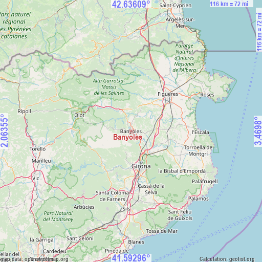
Banyoles GPS coordinates[2]
42° 7' 0.012" North, 2° 46' 0.012" East
| Map corner | latitude | longitude |
|---|---|---|
| Upper-left | 42.63609°, | 2.06355° |
| Center: | 42.11667°, | 2.76667° |
| Lower-right: | 41.59296°, | 3.4698° |
| Map W x H: | 116×116 km | = 72.1×72.1mi |
| max Lat: | 43.74134° ⇑23.1% North |
| Banyoles: | 42.11667° |
| min Lat: | ⇓76.9% South 27.64134° |
| min Long | Banyoles | max Long |
| -18.00367° | 2.76667° | 4.2899° |
| W 97.5%⇐ | ⇒2.5% E |
Elevation
Elevation of Banyoles is 170 m = 558 ft, and this is 428 m = 1404 ft below average elevation for this country.
| Max E: |
1682 m = 5518 ft | 82.8% |
| Avg. | 598 m = 1962 ft | |
| Banyoles | 170 m = 558 ft | |
Min E: |
0 m = 0 ft | 17.2% |
See also: Spain elevation on elevation.city.
Geographical zone
Banyoles is located in North temperate zone (between Tropic of Cancer and the Arctic Circle). Distance of this Northern Tropic circle is 2077 km =1290.6 mi to South.| Distance of | km | miles | from Banyoles |
|---|---|---|---|
| North Pole | 5324.1 | 3308.2 | to North |
| Arctic Circle | 2718.2 | 1689 | to North |
| Tropic Cancer | 2077 | 1290.6 | to South |
| Equator | 4682.9 | 2909.8 | to South |


Nearby cities:
15 places around Banyoles: (largest is in red/bold)
• Besalú
10.7 km =6.6 mi,  328°
328°
• Bàscara
12.8 km =8 mi,  67°
67°
• Camós
3.2 km =2 mi,  185°
185°
• Cornellà del Terri
5.5 km =3.4 mi,  131°
131°
• Crespià
7.9 km =4.9 mi,  20°
20°
• Esponellà
6.2 km =3.9 mi,  26°
26°
• Fontcoberta
3.3 km =2.1 mi,  56°
56°
• Mieres
10.6 km =6.6 mi,  273°
273°
• Palol de Revardit
6.2 km =3.9 mi,  153°
153°
• Porqueres
2.1 km =1.3 mi, 270°
• Sant Ferriol
12.4 km =7.7 mi,  318°
318°
• Sant Julià de Ramis
12.1 km =7.5 mi,  143°
143°
• Sant Miquel de Campmajor
7.1 km =4.4 mi,  285°
285°
• Sarrià de Ter
12.4 km =7.7 mi, 153°
• Vilademuls
10.3 km =6.4 mi,  76°
76°
Sources, notices
• [Note1] Compared only with cities in Spain existing in our database
• [Src1] Map data: © OpenStreetMap contributors (CC-BY-SA)
• [Src2] Other city data from geonames.org with taken over terms of usage.
• [Src3] Geographical zone / Annual Mean Temperature by Robert A. Rohde @ Wikipedia
