Calzadilla geodata
Calzadilla (Extremadura) is a seat of a third-order administrative division; located in Spain in Europe/Madrid (GMT+2) time zone. With population of 476 people, there are 3943 cities with bigger population in this country. Compared to other cities in Spain, 69.4% of cities are located further ↑North; 91.4% of cities are located further →East and 71.5% of cities have higher elevation than Calzadilla. Note1


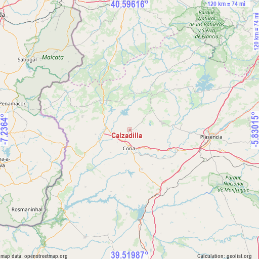
Calzadilla GPS coordinates[2]
40° 3' 36.504" North, 6° 31' 59.808" West
| Map corner | latitude | longitude |
|---|---|---|
| Upper-left | 40.59616°, | -7.2364° |
| Center: | 40.06014°, | -6.53328° |
| Lower-right: | 39.51987°, | -5.83015° |
| Map W x H: | 119.7×119.7 km | = 74.4×74.4mi |
| max Lat: | 43.74134° ⇑69.4% North |
| Calzadilla: | 40.06014° |
| min Lat: | ⇓30.6% South 27.64134° |
| min Long | Calzadilla | max Long |
| -18.00367° | -6.53328° | 4.2899° |
| W 8.6%⇐ | ⇒91.4% E |
Elevation
Elevation of Calzadilla is 356 m = 1168 ft, and this is 242 m = 794 ft below average elevation for this country.
| Max E: |
1682 m = 5518 ft | 71.5% |
| Avg. | 598 m = 1962 ft | |
| Calzadilla | 356 m = 1168 ft | |
Min E: |
0 m = 0 ft | 28.5% |
See also: Spain elevation on elevation.city.
Geographical zone
Calzadilla is located in North temperate zone (between Tropic of Cancer and the Arctic Circle). Distance of this Northern Tropic circle is 1848.4 km =1148.5 mi to South.| Distance of | km | miles | from Calzadilla |
|---|---|---|---|
| North Pole | 5552.8 | 3450.3 | to North |
| Arctic Circle | 2946.9 | 1831.1 | to North |
| Tropic Cancer | 1848.4 | 1148.5 | to South |
| Equator | 4454.3 | 2767.8 | to South |


Nearby cities:
15 places around Calzadilla: (largest is in red/bold)
• Casas de Don Gómez
8.1 km =5 mi,  225°
225°
• Casillas de Coria
13.8 km =8.6 mi,  220°
220°
• Coria
8.5 km =5.3 mi,  181°
181°
• Guijo de Coria
7.5 km =4.7 mi,  52°
52°
• Guijo de Galisteo
11.1 km =6.9 mi,  70°
70°
• Huélaga
7 km =4.3 mi,  266°
266°
• Montehermoso
15.9 km =9.9 mi,  78°
78°
• Moraleja
10.8 km =6.7 mi, 273°
• Morcillo
12.4 km =7.7 mi,  111°
111°
• Perales del Puerto
16.5 km =10.3 mi,  310°
310°
• Portaje
16 km =9.9 mi,  188°
188°
• Pozuelo de Zarzón
14.1 km =8.8 mi, 45°
• Santibáñez el Alto
14 km =8.7 mi,  354°
354°
• Villa del Campo
12.9 km =8 mi,  44°
44°
• Villasbuenas de Gata
15.4 km =9.6 mi,  329°
329°
Sources, notices
• [Note1] Compared only with cities in Spain existing in our database
• [Src1] Map data: © OpenStreetMap contributors (CC-BY-SA)
• [Src2] Other city data from geonames.org with taken over terms of usage.
• [Src3] Geographical zone / Annual Mean Temperature by Robert A. Rohde @ Wikipedia
