Huélaga geodata
Huélaga (Extremadura) is a seat of a third-order administrative division; located in Spain in Europe/Madrid (GMT+2) time zone. With population of 192 people, there are 5092 cities with bigger population in this country. Compared to other cities in Spain, 69.4% of cities are located further ↑North; 92% of cities are located further →East and 76.1% of cities have higher elevation than Huélaga. Note1


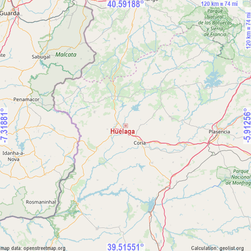
Huélaga GPS coordinates[2]
40° 3' 20.952" North, 6° 36' 56.448" West
| Map corner | latitude | longitude |
|---|---|---|
| Upper-left | 40.59188°, | -7.31881° |
| Center: | 40.05582°, | -6.61568° |
| Lower-right: | 39.51551°, | -5.91256° |
| Map W x H: | 119.7×119.7 km | = 74.4×74.4mi |
| max Lat: | 43.74134° ⇑69.4% North |
| Huélaga: | 40.05582° |
| min Lat: | ⇓30.6% South 27.64134° |
| min Long | Huélaga | max Long |
| -18.00367° | -6.61568° | 4.2899° |
| W 8%⇐ | ⇒92% E |
Elevation
Elevation of Huélaga is 284 m = 932 ft, and this is 314 m = 1030 ft below average elevation for this country.
| Max E: |
1682 m = 5518 ft | 76.1% |
| Avg. | 598 m = 1962 ft | |
| Huélaga | 284 m = 932 ft | |
Min E: |
0 m = 0 ft | 23.9% |
See also: Spain elevation on elevation.city.
Geographical zone
Huélaga is located in North temperate zone (between Tropic of Cancer and the Arctic Circle). Distance of this Northern Tropic circle is 1847.9 km =1148.2 mi to South.| Distance of | km | miles | from Huélaga |
|---|---|---|---|
| North Pole | 5553.3 | 3450.7 | to North |
| Arctic Circle | 2947.4 | 1831.4 | to North |
| Tropic Cancer | 1847.9 | 1148.2 | to South |
| Equator | 4453.8 | 2767.5 | to South |


Nearby cities:
15 places around Huélaga: (largest is in red/bold)
• Cachorrilla
16.2 km =10.1 mi,  196°
196°
• Calzadilla
7 km =4.3 mi,  86°
86°
• Casas de Don Gómez
5.3 km =3.3 mi,  166°
166°
• Casillas de Coria
10.2 km =6.3 mi,  190°
190°
• Cilleros
16.4 km =10.2 mi,  293°
293°
• Coria
10.5 km =6.5 mi,  139°
139°
• Guijo de Coria
13.9 km =8.6 mi,  68°
68°
• Guijo de Galisteo
18 km =11.2 mi,  76°
76°
• Hoyos
15.7 km =9.8 mi,  325°
325°
• Moraleja
4 km =2.5 mi, 288°
• Perales del Puerto
12.5 km =7.8 mi, 333°
• Pescueza
15.5 km =9.6 mi, 189°
• Portaje
16 km =9.9 mi,  163°
163°
• Santibáñez el Alto
15.5 km =9.6 mi,  21°
21°
• Villasbuenas de Gata
13.7 km =8.5 mi,  356°
356°
Sources, notices
• [Note1] Compared only with cities in Spain existing in our database
• [Src1] Map data: © OpenStreetMap contributors (CC-BY-SA)
• [Src2] Other city data from geonames.org with taken over terms of usage.
• [Src3] Geographical zone / Annual Mean Temperature by Robert A. Rohde @ Wikipedia
