Moraleja geodata
Moraleja (Extremadura) is a seat of a third-order administrative division; located in Spain in Europe/Madrid (GMT+2) time zone. With population of 7,995 people, there are 937 cities with bigger population in this country. Compared to other cities in Spain, 69.1% of cities are located further ↑North; 92.5% of cities are located further →East and 77.6% of cities have higher elevation than Moraleja. Note1


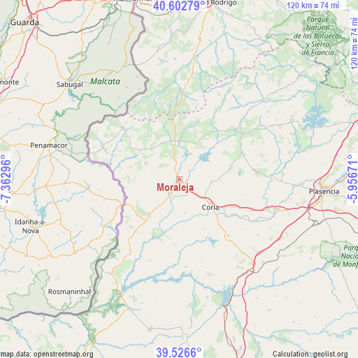
Moraleja GPS coordinates[2]
40° 4' 0.552" North, 6° 39' 35.388" West
| Map corner | latitude | longitude |
|---|---|---|
| Upper-left | 40.60279°, | -7.36296° |
| Center: | 40.06682°, | -6.65983° |
| Lower-right: | 39.5266°, | -5.95671° |
| Map W x H: | 119.7×119.7 km | = 74.4×74.4mi |
| max Lat: | 43.74134° ⇑69.1% North |
| Moraleja: | 40.06682° |
| min Lat: | ⇓30.9% South 27.64134° |
| min Long | Moraleja | max Long |
| -18.00367° | -6.65983° | 4.2899° |
| W 7.5%⇐ | ⇒92.5% E |
Elevation
Elevation of Moraleja is 262 m = 860 ft, and this is 336 m = 1102 ft below average elevation for this country.
| Max E: |
1682 m = 5518 ft | 77.6% |
| Avg. | 598 m = 1962 ft | |
| Moraleja | 262 m = 860 ft | |
Min E: |
0 m = 0 ft | 22.4% |
See also: Spain elevation on elevation.city.
Geographical zone
Moraleja is located in North temperate zone (between Tropic of Cancer and the Arctic Circle). Distance of this Northern Tropic circle is 1849.1 km =1149 mi to South.| Distance of | km | miles | from Moraleja |
|---|---|---|---|
| North Pole | 5552 | 3449.9 | to North |
| Arctic Circle | 2946.2 | 1830.7 | to North |
| Tropic Cancer | 1849.1 | 1149 | to South |
| Equator | 4455 | 2768.2 | to South |


Nearby cities:
15 places around Moraleja: (largest is in red/bold)
• Acebo
15.7 km =9.8 mi,  341°
341°
• Cachorrilla
16.8 km =10.4 mi,  182°
182°
• Calzadilla
10.8 km =6.7 mi,  93°
93°
• Casas de Don Gómez
8.1 km =5 mi,  141°
141°
• Casillas de Coria
11.4 km =7.1 mi,  170°
170°
• Cilleros
12.5 km =7.8 mi,  295°
295°
• Coria
14 km =8.7 mi,  131°
131°
• Guijo de Coria
17.1 km =10.6 mi,  77°
77°
• Hoyos
12.7 km =7.9 mi, 335°
• Huélaga
4 km =2.5 mi,  108°
108°
• Perales del Puerto
10.1 km =6.3 mi,  349°
349°
• Pescueza
16.6 km =10.3 mi, 175°
• Santibáñez el Alto
16.3 km =10.1 mi,  35°
35°
• Villamiel
17 km =10.6 mi,  321°
321°
• Villasbuenas de Gata
12.8 km =8 mi,  12°
12°
Sources, notices
• [Note1] Compared only with cities in Spain existing in our database
• [Src1] Map data: © OpenStreetMap contributors (CC-BY-SA)
• [Src2] Other city data from geonames.org with taken over terms of usage.
• [Src3] Geographical zone / Annual Mean Temperature by Robert A. Rohde @ Wikipedia
