Coria geodata
Coria (Extremadura) is a seat of a third-order administrative division; located in Spain in Europe/Madrid (GMT+2) time zone. With population of 12,896 people, there are 710 cities with bigger population in this country. Compared to other cities in Spain, 70.4% of cities are located further ↑North; 91.4% of cities are located further →East and 77.1% of cities have higher elevation than Coria. Note1


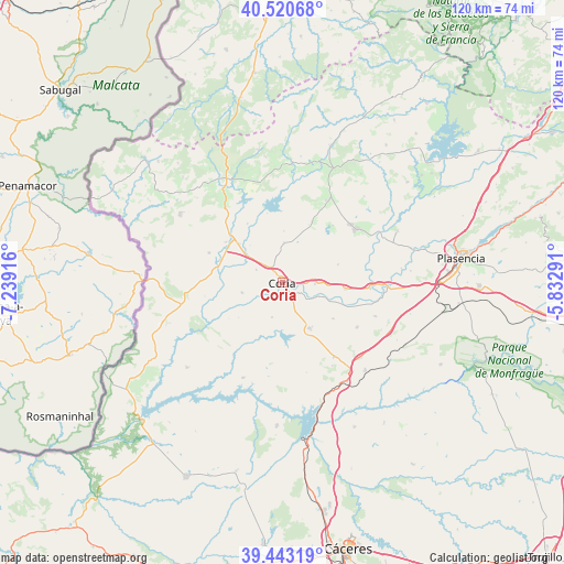
Coria GPS coordinates[2]
39° 59' 2.616" North, 6° 32' 9.708" West
| Map corner | latitude | longitude |
|---|---|---|
| Upper-left | 40.52068°, | -7.23916° |
| Center: | 39.98406°, | -6.53603° |
| Lower-right: | 39.44319°, | -5.83291° |
| Map W x H: | 119.8×119.8 km | = 74.4×74.4mi |
| max Lat: | 43.74134° ⇑70.4% North |
| Coria: | 39.98406° |
| min Lat: | ⇓29.6% South 27.64134° |
| min Long | Coria | max Long |
| -18.00367° | -6.53603° | 4.2899° |
| W 8.6%⇐ | ⇒91.4% E |
Elevation
Elevation of Coria is 268 m = 879 ft, and this is 330 m = 1083 ft below average elevation for this country.
| Max E: |
1682 m = 5518 ft | 77.1% |
| Avg. | 598 m = 1962 ft | |
| Coria | 268 m = 879 ft | |
Min E: |
0 m = 0 ft | 22.9% |
See also: Spain elevation on elevation.city.
Geographical zone
Coria is located in North temperate zone (between Tropic of Cancer and the Arctic Circle). Distance of this Northern Tropic circle is 1839.9 km =1143.3 mi to South.| Distance of | km | miles | from Coria |
|---|---|---|---|
| North Pole | 5561.3 | 3455.6 | to North |
| Arctic Circle | 2955.4 | 1836.4 | to North |
| Tropic Cancer | 1839.9 | 1143.3 | to South |
| Equator | 4445.8 | 2762.5 | to South |


Nearby cities:
15 places around Coria: (largest is in red/bold)
• Cachorrilla
13.7 km =8.5 mi,  236°
236°
• Calzadilla
8.5 km =5.3 mi,  1°
1°
• Casas de Don Gómez
6.2 km =3.9 mi,  297°
297°
• Casillas de Coria
8.9 km =5.5 mi,  256°
256°
• Guijo de Coria
14.4 km =8.9 mi,  25°
25°
• Guijo de Galisteo
16.2 km =10.1 mi,  41°
41°
• Holguera
18.5 km =11.5 mi,  120°
120°
• Huélaga
10.5 km =6.5 mi,  319°
319°
• Montehermoso
19.6 km =12.2 mi,  53°
53°
• Moraleja
14 km =8.7 mi,  311°
311°
• Morcillo
12.4 km =7.7 mi,  71°
71°
• Pescueza
11.9 km =7.4 mi,  231°
231°
• Portaje
7.7 km =4.8 mi,  196°
196°
• Portezuelo
19.8 km =12.3 mi,  164°
164°
• Torrejoncillo
11.3 km =7 mi,  148°
148°
Sources, notices
• [Note1] Compared only with cities in Spain existing in our database
• [Src1] Map data: © OpenStreetMap contributors (CC-BY-SA)
• [Src2] Other city data from geonames.org with taken over terms of usage.
• [Src3] Geographical zone / Annual Mean Temperature by Robert A. Rohde @ Wikipedia
