Burgohondo geodata
Burgohondo (Castille and León) is a seat of a third-order administrative division; located in Spain in Europe/Madrid (GMT+2) time zone. With population of 1,180 people, there are 2737 cities with bigger population in this country. Compared to other cities in Spain, 63.7% of cities are located further ↑North; 69.6% of cities are located further →East and 74.4% of cities have lower elevation than Burgohondo. Note1
Administrative division(s):
- Level 1: Castille and León
- Level 2: Provincia de Ávila
- Level 3: Burgohondo


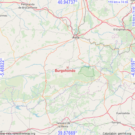
Burgohondo GPS coordinates[2]
40° 24' 50.976" North, 4° 47' 6.324" West
| Map corner | latitude | longitude |
|---|---|---|
| Upper-left | 40.94737°, | -5.48822° |
| Center: | 40.41416°, | -4.78509° |
| Lower-right: | 39.87669°, | -4.08197° |
| Map W x H: | 119×119 km | = 73.9×73.9mi |
| max Lat: | 43.74134° ⇑63.7% North |
| Burgohondo: | 40.41416° |
| min Lat: | ⇓36.3% South 27.64134° |
| min Long | Burgohondo | max Long |
| -18.00367° | -4.78509° | 4.2899° |
| W 30.4%⇐ | ⇒69.6% E |
Elevation
Elevation of Burgohondo is 847 m = 2779 ft, and this is 249 m = 817 ft above average elevation for this country.
| Max E: |
1682 m = 5518 ft | 25.6% |
| Burgohondo | 847 m 2779 ft | |
| Avg. | 598 m = 1962 ft | |
Min E: |
0 m = 0 ft | 74.4% |
See also: Spain elevation on elevation.city.
Geographical zone
Burgohondo is located in North temperate zone (between Tropic of Cancer and the Arctic Circle). Distance of this Northern Tropic circle is 1887.7 km =1173 mi to South.| Distance of | km | miles | from Burgohondo |
|---|---|---|---|
| North Pole | 5513.4 | 3425.9 | to North |
| Arctic Circle | 2907.5 | 1806.6 | to North |
| Tropic Cancer | 1887.7 | 1173 | to South |
| Equator | 4493.6 | 2792.2 | to South |


Nearby cities:
15 places around Burgohondo: (largest is in red/bold)
• Barraco
13.8 km =8.6 mi,  59°
59°
• Casavieja
14.6 km =9.1 mi,  173°
173°
• Mijares
13.8 km =8.6 mi,  198°
198°
• Navalacruz
12.7 km =7.9 mi,  283°
283°
• Navalmoral
5.3 km =3.3 mi,  15°
15°
• Navalosa
12.3 km =7.6 mi,  263°
263°
• Navaluenga
6.5 km =4 mi,  92°
92°
• Navaquesera
10.7 km =6.6 mi, 276°
• Navarredondilla
5.4 km =3.4 mi,  324°
324°
• Navarrevisca
10.7 km =6.6 mi,  238°
238°
• Navatalgordo
7.3 km =4.5 mi,  270°
270°
• Piedralaves
13 km =8.1 mi,  146°
146°
• San Juan de la Nava
11.3 km =7 mi,  50°
50°
• San Juan del Molinillo
5.7 km =3.5 mi,  331°
331°
• Serranillos
13.8 km =8.6 mi,  231°
231°
Sources, notices
• [Note1] Compared only with cities in Spain existing in our database
• [Src1] Map data: © OpenStreetMap contributors (CC-BY-SA)
• [Src2] Other city data from geonames.org with taken over terms of usage.
• [Src3] Geographical zone / Annual Mean Temperature by Robert A. Rohde @ Wikipedia
