Burbáguena geodata
Burbáguena (Aragon) is a seat of a third-order administrative division; located in Spain in Europe/Madrid (GMT+2) time zone. With population of 334 people, there are 4375 cities with bigger population in this country. Compared to other cities in Spain, 51.2% of cities are located further ↑North; 74.4% of cities are located further ←West and 71.3% of cities have lower elevation than Burbáguena. Note1


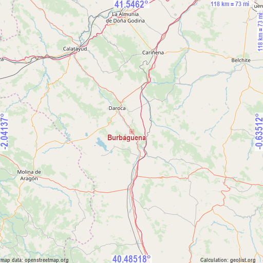
Burbáguena GPS coordinates[2]
41° 1' 4.188" North, 1° 20' 17.7" West
| Map corner | latitude | longitude |
|---|---|---|
| Upper-left | 41.5462°, | -2.04137° |
| Center: | 41.01783°, | -1.33825° |
| Lower-right: | 40.48518°, | -0.63512° |
| Map W x H: | 118×118 km | = 73.3×73.3mi |
| max Lat: | 43.74134° ⇑51.2% North |
| Burbáguena: | 41.01783° |
| min Lat: | ⇓48.8% South 27.64134° |
| min Long | Burbáguena | max Long |
| -18.00367° | -1.33825° | 4.2899° |
| W 74.4%⇐ | ⇒25.6% E |
Elevation
Elevation of Burbáguena is 823 m = 2700 ft, and this is 225 m = 738 ft above average elevation for this country.
| Max E: |
1682 m = 5518 ft | 28.7% |
| Burbáguena | 823 m 2700 ft | |
| Avg. | 598 m = 1962 ft | |
Min E: |
0 m = 0 ft | 71.3% |
See also: Spain elevation on elevation.city.
Geographical zone
Burbáguena is located in North temperate zone (between Tropic of Cancer and the Arctic Circle). Distance of this Northern Tropic circle is 1954.8 km =1214.7 mi to South.| Distance of | km | miles | from Burbáguena |
|---|---|---|---|
| North Pole | 5446.3 | 3384.2 | to North |
| Arctic Circle | 2840.4 | 1764.9 | to North |
| Tropic Cancer | 1954.8 | 1214.7 | to South |
| Equator | 4560.8 | 2833.9 | to South |


Nearby cities:
15 places around Burbáguena: (largest is in red/bold)
• Anento
5.8 km =3.6 mi,  3°
3°
• Báguena
3.1 km =1.9 mi,  328°
328°
• Calamocha
11.5 km =7.1 mi,  162°
162°
• Castejón de Tornos
7.9 km =4.9 mi,  253°
253°
• Daroca
12.5 km =7.8 mi, 329°
• Ferreruela de Huerva
10.1 km =6.3 mi,  60°
60°
• Lagueruela
12.5 km =7.8 mi,  77°
77°
• Lechón
8.8 km =5.5 mi,  30°
30°
• Nombrevilla
10.1 km =6.3 mi,  350°
350°
• San Martín del Río
6.8 km =4.2 mi,  322°
322°
• Tornos
10.2 km =6.3 mi,  232°
232°
• Val de San Martín
10.3 km =6.4 mi,  295°
295°
• Valdehorna
9.4 km =5.8 mi,  310°
310°
• Villahermosa del Campo
12.7 km =7.9 mi,  36°
36°
• Villanueva de Jiloca
7.8 km =4.8 mi, 326°
Sources, notices
• [Note1] Compared only with cities in Spain existing in our database
• [Src1] Map data: © OpenStreetMap contributors (CC-BY-SA)
• [Src2] Other city data from geonames.org with taken over terms of usage.
• [Src3] Geographical zone / Annual Mean Temperature by Robert A. Rohde @ Wikipedia
