Calamocha geodata
Calamocha (Aragon) is a seat of a third-order administrative division; located in Spain in Europe/Madrid (GMT+2) time zone. With population of 4,313 people, there are 1417 cities with bigger population in this country. Compared to other cities in Spain, 53.5% of cities are located further ↑North; 74.8% of cities are located further ←West and 79.3% of cities have lower elevation than Calamocha. Note1


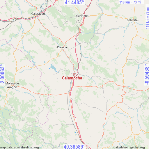
Calamocha GPS coordinates[2]
40° 55' 9.588" North, 1° 17' 51" West
| Map corner | latitude | longitude |
|---|---|---|
| Upper-left | 41.4485°, | -2.00063° |
| Center: | 40.91933°, | -1.2975° |
| Lower-right: | 40.38589°, | -0.59438° |
| Map W x H: | 118.2×118.1 km | = 73.4×73.4mi |
| max Lat: | 43.74134° ⇑53.5% North |
| Calamocha: | 40.91933° |
| min Lat: | ⇓46.5% South 27.64134° |
| min Long | Calamocha | max Long |
| -18.00367° | -1.2975° | 4.2899° |
| W 74.8%⇐ | ⇒25.2% E |
Elevation
Elevation of Calamocha is 891 m = 2923 ft, and this is 293 m = 961 ft above average elevation for this country.
| Max E: |
1682 m = 5518 ft | 20.7% |
| Calamocha | 891 m 2923 ft | |
| Avg. | 598 m = 1962 ft | |
Min E: |
0 m = 0 ft | 79.3% |
See also: Spain elevation on elevation.city.
Geographical zone
Calamocha is located in North temperate zone (between Tropic of Cancer and the Arctic Circle). Distance of this Northern Tropic circle is 1943.9 km =1207.9 mi to South.| Distance of | km | miles | from Calamocha |
|---|---|---|---|
| North Pole | 5457.3 | 3391 | to North |
| Arctic Circle | 2851.4 | 1771.8 | to North |
| Tropic Cancer | 1943.9 | 1207.9 | to South |
| Equator | 4549.8 | 2827.1 | to South |


Nearby cities:
15 places around Calamocha: (largest is in red/bold)
• Barrachina
13.6 km =8.5 mi,  100°
100°
• Bañón
12.7 km =7.9 mi,  135°
135°
• Bello
16.9 km =10.5 mi,  271°
271°
• Burbáguena
11.5 km =7.1 mi,  342°
342°
• Báguena
14.5 km =9 mi, 339°
• Caminreal
9.2 km =5.7 mi,  194°
194°
• Castejón de Tornos
14 km =8.7 mi,  308°
308°
• Cosa
16.5 km =10.3 mi,  125°
125°
• Ferreruela de Huerva
16.9 km =10.5 mi,  18°
18°
• Fuentes Claras
6.5 km =4 mi,  198°
198°
• Lagueruela
16.3 km =10.1 mi,  32°
32°
• Monreal del Campo
15.4 km =9.6 mi, 198°
• Tornos
12.4 km =7.7 mi,  292°
292°
• Torralba de los Sisones
13.9 km =8.6 mi,  256°
256°
• Torrijo del Campo
10.9 km =6.8 mi, 197°
Sources, notices
• [Note1] Compared only with cities in Spain existing in our database
• [Src1] Map data: © OpenStreetMap contributors (CC-BY-SA)
• [Src2] Other city data from geonames.org with taken over terms of usage.
• [Src3] Geographical zone / Annual Mean Temperature by Robert A. Rohde @ Wikipedia
