Báguena geodata
Báguena (Aragon) is a seat of a third-order administrative division; located in Spain in Europe/Madrid (GMT+2) time zone. With population of 395 people, there are 4155 cities with bigger population in this country. Compared to other cities in Spain, 50.6% of cities are located further ↑North; 74.2% of cities are located further ←West and 69.8% of cities have lower elevation than Báguena. Note1


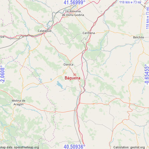
Báguena GPS coordinates[2]
41° 2' 30.516" North, 1° 21' 27.612" West
| Map corner | latitude | longitude |
|---|---|---|
| Upper-left | 41.56999°, | -2.0608° |
| Center: | 41.04181°, | -1.35767° |
| Lower-right: | 40.50936°, | -0.65455° |
| Map W x H: | 117.9×117.9 km | = 73.3×73.3mi |
| max Lat: | 43.74134° ⇑50.6% North |
| Báguena: | 41.04181° |
| min Lat: | ⇓49.4% South 27.64134° |
| min Long | Báguena | max Long |
| -18.00367° | -1.35767° | 4.2899° |
| W 74.2%⇐ | ⇒25.8% E |
Elevation
Elevation of Báguena is 813 m = 2667 ft, and this is 215 m = 705 ft above average elevation for this country.
| Max E: |
1682 m = 5518 ft | 30.2% |
| Báguena | 813 m 2667 ft | |
| Avg. | 598 m = 1962 ft | |
Min E: |
0 m = 0 ft | 69.8% |
See also: Spain elevation on elevation.city.
Geographical zone
Báguena is located in North temperate zone (between Tropic of Cancer and the Arctic Circle). Distance of this Northern Tropic circle is 1957.5 km =1216.3 mi to South.| Distance of | km | miles | from Báguena |
|---|---|---|---|
| North Pole | 5443.6 | 3382.5 | to North |
| Arctic Circle | 2837.8 | 1763.3 | to North |
| Tropic Cancer | 1957.5 | 1216.3 | to South |
| Equator | 4563.4 | 2835.6 | to South |


Nearby cities:
15 places around Báguena: (largest is in red/bold)
• Anento
3.7 km =2.3 mi,  33°
33°
• Balconchán
10 km =6.2 mi,  300°
300°
• Burbáguena
3.1 km =1.9 mi,  148°
148°
• Castejón de Tornos
7.7 km =4.8 mi,  230°
230°
• Daroca
9.4 km =5.8 mi,  329°
329°
• Ferreruela de Huerva
10.7 km =6.6 mi,  77°
77°
• Lechón
7.9 km =4.9 mi,  50°
50°
• Nombrevilla
7.3 km =4.5 mi,  359°
359°
• Retascón
11.5 km =7.1 mi,  349°
349°
• San Martín del Río
3.7 km =2.3 mi,  317°
317°
• Tornos
10.9 km =6.8 mi,  215°
215°
• Val de San Martín
7.9 km =4.9 mi,  283°
283°
• Valdehorna
6.5 km =4 mi, 301°
• Villanueva de Jiloca
4.7 km =2.9 mi, 325°
• Villarroya del Campo
11.6 km =7.2 mi,  14°
14°
Sources, notices
• [Note1] Compared only with cities in Spain existing in our database
• [Src1] Map data: © OpenStreetMap contributors (CC-BY-SA)
• [Src2] Other city data from geonames.org with taken over terms of usage.
• [Src3] Geographical zone / Annual Mean Temperature by Robert A. Rohde @ Wikipedia
