Buniel geodata
Buniel (Castille and León) is a seat of a third-order administrative division; located in Spain in Europe/Madrid (GMT+2) time zone. With population of 269 people, there are 4634 cities with bigger population in this country. Compared to other cities in Spain, 82.1% of cities are located further ↓South; 57.1% of cities are located further →East and 71.3% of cities have lower elevation than Buniel. Note1


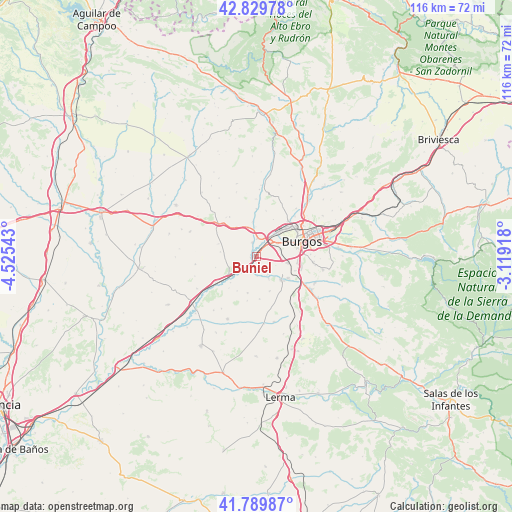
Buniel GPS coordinates[2]
42° 18' 43.092" North, 3° 49' 20.28" West
| Map corner | latitude | longitude |
|---|---|---|
| Upper-left | 42.82978°, | -4.52543° |
| Center: | 42.31197°, | -3.8223° |
| Lower-right: | 41.78987°, | -3.11918° |
| Map W x H: | 115.6×115.6 km | = 71.8×71.8mi |
| max Lat: | 43.74134° ⇑17.9% North |
| Buniel: | 42.31197° |
| min Lat: | ⇓82.1% South 27.64134° |
| min Long | Buniel | max Long |
| -18.00367° | -3.8223° | 4.2899° |
| W 42.9%⇐ | ⇒57.1% E |
Elevation
Elevation of Buniel is 823 m = 2700 ft, and this is 225 m = 738 ft above average elevation for this country.
| Max E: |
1682 m = 5518 ft | 28.7% |
| Buniel | 823 m 2700 ft | |
| Avg. | 598 m = 1962 ft | |
Min E: |
0 m = 0 ft | 71.3% |
See also: Spain elevation on elevation.city.
Geographical zone
Buniel is located in North temperate zone (between Tropic of Cancer and the Arctic Circle). Distance of this Northern Tropic circle is 2098.7 km =1304.1 mi to South.| Distance of | km | miles | from Buniel |
|---|---|---|---|
| North Pole | 5302.4 | 3294.8 | to North |
| Arctic Circle | 2696.5 | 1675.5 | to North |
| Tropic Cancer | 2098.7 | 1304.1 | to South |
| Equator | 4704.7 | 2923.4 | to South |


Nearby cities:
15 places around Buniel: (largest is in red/bold)
• Albillos
4.8 km =3 mi,  145°
145°
• Arcos
7.5 km =4.7 mi,  132°
132°
• Burgos
10.4 km =6.5 mi,  71°
71°
• Cayuela
4.4 km =2.7 mi,  176°
176°
• Celada del Camino
10.6 km =6.6 mi,  239°
239°
• Estépar
7.4 km =4.6 mi, 238°
• Frandovínez
1.3 km =0.8 mi,  261°
261°
• Hornillos del Camino
9 km =5.6 mi,  289°
289°
• Isar
10.4 km =6.5 mi,  301°
301°
• Rabé de las Calzadas
3.3 km =2.1 mi,  343°
343°
• San Mamés de Burgos
3.6 km =2.2 mi,  40°
40°
• Tardajos
4.2 km =2.6 mi,  6°
6°
• Villagonzalo-Pedernales
7.2 km =4.5 mi,  99°
99°
• Villalbilla de Burgos
5.2 km =3.2 mi, 40°
• Villariezo
8.7 km =5.4 mi,  122°
122°
Sources, notices
• [Note1] Compared only with cities in Spain existing in our database
• [Src1] Map data: © OpenStreetMap contributors (CC-BY-SA)
• [Src2] Other city data from geonames.org with taken over terms of usage.
• [Src3] Geographical zone / Annual Mean Temperature by Robert A. Rohde @ Wikipedia
