Villagonzalo-Pedernales geodata
Villagonzalo-Pedernales (Castille and León) is a populated place; located in Spain in Europe/Madrid (GMT+2) time zone. With population of 1,110 people, there are 2814 cities with bigger population in this country. Compared to other cities in Spain, 81.8% of cities are located further ↓South; 55.9% of cities are located further →East and 80.4% of cities have lower elevation than Villagonzalo-Pedernales. Note1
Administrative division(s):
- Level 1: Castille and León
- Level 2: Provincia de Burgos
- Level 3: Villagonzalo Pedernales
Current local time in Villagonzalo-Pedernales:
11:09 PM, ThursdayDifference from your time zone: hours


Villagonzalo-Pedernales GPS coordinates[2]
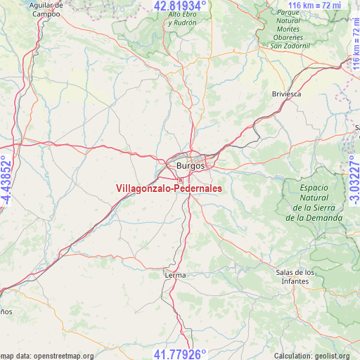
42° 18' 5.22" North, 3° 44' 7.404" West
| Map corner | latitude | longitude |
|---|---|---|
| Upper-left | 42.81934°, | -4.43852° |
| Center: | 42.30145°, | -3.73539° |
| Lower-right: | 41.77926°, | -3.03227° |
| Map W x H: | 115.6×115.6 km | = 71.8×71.8mi |
| max Lat: | 43.74134° ⇑18.2% North |
| Villagonzalo-Pedernales: | 42.30145° |
| min Lat: | ⇓81.8% South 27.64134° |
| min Long | Villagonzalo-Pe | max Long |
| -18.00367° | -3.73539° | 4.2899° |
| W 44.1%⇐ | ⇒55.9% E |
Elevation
Elevation of Villagonzalo-Pedernales is 901 m = 2956 ft, and this is 303 m = 994 ft above average elevation for this country.
| Max E: |
1682 m = 5518 ft | 19.6% |
| Villagonzalo-Pedernales | 901 m 2956 ft | |
| Avg. | 598 m = 1962 ft | |
Min E: |
0 m = 0 ft | 80.4% |
See also: Spain elevation on elevation.city.
Geographical zone
Villagonzalo-Pedernales is located in North temperate zone (between Tropic of Cancer and the Arctic Circle). Distance of this Northern Tropic circle is 2097.6 km =1303.4 mi to South.| Distance of | km | miles | from Villagonzalo-Pedernales |
|---|---|---|---|
| North Pole | 5303.6 | 3295.5 | to North |
| Arctic Circle | 2697.7 | 1676.3 | to North |
| Tropic Cancer | 2097.6 | 1303.4 | to South |
| Equator | 4703.5 | 2922.6 | to South |


Nearby cities:
15 places around Villagonzalo-Pedernales: (largest is in red/bold)
• Albillos
5.2 km =3.2 mi,  238°
238°
• Arcos
4.2 km =2.6 mi,  202°
202°
• Buniel
7.2 km =4.5 mi,  279°
279°
• Burgos
5.2 km =3.2 mi,  32°
32°
• Cardeñadijo
5.6 km =3.5 mi,  89°
89°
• Cayuela
7.6 km =4.7 mi, 244°
• Frandovínez
8.5 km =5.3 mi, 276°
• Gamonal
8 km =5 mi,  39°
39°
• Modúbar de la Emparedada
7.7 km =4.8 mi,  125°
125°
• Saldaña de Burgos
5.7 km =3.5 mi,  146°
146°
• San Mamés de Burgos
6.2 km =3.9 mi,  309°
309°
• Sarracín
6.3 km =3.9 mi,  139°
139°
• Tardajos
8.5 km =5.3 mi, 308°
• Villalbilla de Burgos
6.4 km =4 mi,  323°
323°
• Villariezo
3.5 km =2.2 mi,  176°
176°
Sources, notices
• [Note1] Compared only with cities in Spain existing in our database
• [Src1] Map data: © OpenStreetMap contributors (CC-BY-SA)
• [Src2] Other city data from geonames.org with taken over terms of usage.
• [Src3] Geographical zone / Annual Mean Temperature by Robert A. Rohde @ Wikipedia
