Alba geodata
Alba (Aragon) is a seat of a third-order administrative division; located in Spain in Europe/Madrid (GMT+2) time zone. With population of 249 people, there are 4745 cities with bigger population in this country. Compared to other cities in Spain, 59.4% of cities are located further ↑North; 74.4% of cities are located further ←West and 87.1% of cities have lower elevation than Alba. Note1


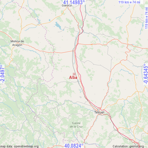
Alba GPS coordinates[2]
40° 37' 5.7" North, 1° 20' 47.688" West
| Map corner | latitude | longitude |
|---|---|---|
| Upper-left | 41.14983°, | -2.0497° |
| Center: | 40.61825°, | -1.34658° |
| Lower-right: | 40.0824°, | -0.64345° |
| Map W x H: | 118.7×118.7 km | = 73.8×73.8mi |
| max Lat: | 43.74134° ⇑59.4% North |
| Alba: | 40.61825° |
| min Lat: | ⇓40.6% South 27.64134° |
| min Long | Alba | max Long |
| -18.00367° | -1.34658° | 4.2899° |
| W 74.4%⇐ | ⇒25.6% E |
Elevation
Elevation of Alba is 982 m = 3222 ft, and this is 384 m = 1260 ft above average elevation for this country.
| Max E: |
1682 m = 5518 ft | 12.9% |
| Alba | 982 m 3222 ft | |
| Avg. | 598 m = 1962 ft | |
Min E: |
0 m = 0 ft | 87.1% |
See also: Spain elevation on elevation.city.
Geographical zone
Alba is located in North temperate zone (between Tropic of Cancer and the Arctic Circle). Distance of this Northern Tropic circle is 1910.4 km =1187.1 mi to South.| Distance of | km | miles | from Alba |
|---|---|---|---|
| North Pole | 5490.7 | 3411.8 | to North |
| Arctic Circle | 2884.8 | 1792.5 | to North |
| Tropic Cancer | 1910.4 | 1187.1 | to South |
| Equator | 4516.3 | 2806.3 | to South |


Nearby cities:
15 places around Alba: (largest is in red/bold)
• Aguatón
11.1 km =6.9 mi,  57°
57°
• Almohaja
7.9 km =4.9 mi,  259°
259°
• Argente
17.4 km =10.8 mi, 63°
• Bueña
12.1 km =7.5 mi,  33°
33°
• Camañas
17.9 km =11.1 mi,  81°
81°
• Monterde de Albarracín
18.2 km =11.3 mi,  222°
222°
• Ojos Negros
18.5 km =11.5 mi,  315°
315°
• Peracense
10.8 km =6.7 mi,  283°
283°
• Pozondón
12.2 km =7.6 mi,  238°
238°
• Ródenas
14.5 km =9 mi, 279°
• Santa Eulalia
6.3 km =3.9 mi,  153°
153°
• Singra
5 km =3.1 mi,  35°
35°
• Villafranca del Campo
8.6 km =5.3 mi,  359°
359°
• Villar del Salz
14.7 km =9.1 mi,  298°
298°
• Villarquemado
13.2 km =8.2 mi, 148°
Sources, notices
• [Note1] Compared only with cities in Spain existing in our database
• [Src1] Map data: © OpenStreetMap contributors (CC-BY-SA)
• [Src2] Other city data from geonames.org with taken over terms of usage.
• [Src3] Geographical zone / Annual Mean Temperature by Robert A. Rohde @ Wikipedia
