Pesquera geodata
Pesquera (Cantabria) is a seat of a third-order administrative division; located in Spain in Europe/Madrid (GMT+2) time zone. With population of 84 people, there are 6094 cities with bigger population in this country. Compared to other cities in Spain, 95.1% of cities are located further ↓South; 61% of cities are located further →East and 54% of cities have higher elevation than Pesquera. Note1


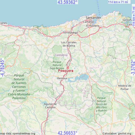
Pesquera GPS coordinates[2]
43° 4' 56.028" North, 4° 4' 45.552" West
| Map corner | latitude | longitude |
|---|---|---|
| Upper-left | 43.59362°, | -4.78245° |
| Center: | 43.08223°, | -4.07932° |
| Lower-right: | 42.56653°, | -3.3762° |
| Map W x H: | 114.2×114.2 km | = 71×71mi |
| max Lat: | 43.74134° ⇑4.9% North |
| Pesquera: | 43.08223° |
| min Lat: | ⇓95.1% South 27.64134° |
| min Long | Pesquera | max Long |
| -18.00367° | -4.07932° | 4.2899° |
| W 39%⇐ | ⇒61% E |
Elevation
Elevation of Pesquera is 612 m = 2008 ft, and this is 14 m = 46 ft above average elevation for this country.
| Max E: |
1682 m = 5518 ft | 54% |
| Pesquera | 612 m 2008 ft | |
| Avg. | 598 m = 1962 ft | |
Min E: |
0 m = 0 ft | 46% |
See also: Spain elevation on elevation.city.
Geographical zone
Pesquera is located in North temperate zone (between Tropic of Cancer and the Arctic Circle). Distance of this Northern Tropic circle is 2184.4 km =1357.3 mi to South.| Distance of | km | miles | from Pesquera |
|---|---|---|---|
| North Pole | 5216.8 | 3241.6 | to North |
| Arctic Circle | 2610.9 | 1622.3 | to North |
| Tropic Cancer | 2184.4 | 1357.3 | to South |
| Equator | 4790.3 | 2976.6 | to South |


Nearby cities:
15 places around Pesquera: (largest is in red/bold)
• Arenas de Iguña
11.5 km =7.1 mi,  13°
13°
• Arija
14.7 km =9.1 mi,  132°
132°
• Brañosera
24.7 km =15.3 mi,  228°
228°
• Bárcena de Pie de Concha
5.2 km =3.2 mi,  20°
20°
• Los Corrales de Buelna
20.2 km =12.6 mi,  1°
1°
• Mataporquera
24 km =14.9 mi,  196°
196°
• Molledo
8.1 km =5 mi, 21°
• Reinosa
10.4 km =6.5 mi,  207°
207°
• Ruente
24.8 km =15.4 mi,  321°
321°
• San Miguel de Aguayo
5.4 km =3.4 mi, 125°
• San Pedro del Romeral
21.5 km =13.4 mi,  80°
80°
• Santiurde de Reinosa
2.3 km =1.4 mi,  188°
188°
• Santiurde de Toranzo
20.7 km =12.9 mi,  33°
33°
• Villaescusa
15.1 km =9.4 mi, 208°
• Villafufre
25.3 km =15.7 mi,  36°
36°
Sources, notices
• [Note1] Compared only with cities in Spain existing in our database
• [Src1] Map data: © OpenStreetMap contributors (CC-BY-SA)
• [Src2] Other city data from geonames.org with taken over terms of usage.
• [Src3] Geographical zone / Annual Mean Temperature by Robert A. Rohde @ Wikipedia
