Villaescusa geodata
Villaescusa (Cantabria) is a populated place; located in Spain in Europe/Madrid (GMT+2) time zone. With population of 3,434 people, there are 1603 cities with bigger population in this country. Compared to other cities in Spain, 94.2% of cities are located further ↓South; 62.1% of cities are located further →East and 77.6% of cities have lower elevation than Villaescusa. Note1
Administrative division(s):
- Level 1: Cantabria
- Level 2: Provincia de Cantabria
- Level 3: Hermandad de Campoo de Suso


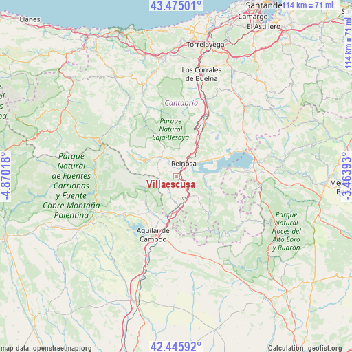
Villaescusa GPS coordinates[2]
42° 57' 45.432" North, 4° 10' 1.416" West
| Map corner | latitude | longitude |
|---|---|---|
| Upper-left | 43.47501°, | -4.87018° |
| Center: | 42.96262°, | -4.16706° |
| Lower-right: | 42.44592°, | -3.46393° |
| Map W x H: | 114.4×114.4 km | = 71.1×71.1mi |
| max Lat: | 43.74134° ⇑5.8% North |
| Villaescusa: | 42.96262° |
| min Lat: | ⇓94.2% South 27.64134° |
| min Long | Villaescusa | max Long |
| -18.00367° | -4.16706° | 4.2899° |
| W 37.9%⇐ | ⇒62.1% E |
Elevation
Elevation of Villaescusa is 875 m = 2871 ft, and this is 277 m = 909 ft above average elevation for this country.
| Max E: |
1682 m = 5518 ft | 22.4% |
| Villaescusa | 875 m 2871 ft | |
| Avg. | 598 m = 1962 ft | |
Min E: |
0 m = 0 ft | 77.6% |
See also: Spain elevation on elevation.city.
Geographical zone
Villaescusa is located in North temperate zone (between Tropic of Cancer and the Arctic Circle). Distance of this Northern Tropic circle is 2171.1 km =1349.1 mi to South.| Distance of | km | miles | from Villaescusa |
|---|---|---|---|
| North Pole | 5230.1 | 3249.8 | to North |
| Arctic Circle | 2624.2 | 1630.6 | to North |
| Tropic Cancer | 2171.1 | 1349.1 | to South |
| Equator | 4777 | 2968.3 | to South |


Nearby cities:
15 places around Villaescusa: (largest is in red/bold)
• Aguilar de Campoo
20.1 km =12.5 mi,  201°
201°
• Arija
18.4 km =11.4 mi,  79°
79°
• Barruelo de Santullán
11.5 km =7.1 mi,  237°
237°
• Berzosilla
22.8 km =14.2 mi,  152°
152°
• Brañosera
11.9 km =7.4 mi,  255°
255°
• Bárcena de Pie de Concha
20.2 km =12.6 mi,  26°
26°
• Mataporquera
9.8 km =6.1 mi,  177°
177°
• Mudá
20.9 km =13 mi, 242°
• Pesquera
15.1 km =9.4 mi, 28°
• Pomar de Valdivia
20.9 km =13 mi, 180°
• Reinosa
4.7 km =2.9 mi, 29°
• Salinas de Pisuerga
21.2 km =13.2 mi,  234°
234°
• San Cebrián de Mudá
19.5 km =12.1 mi,  246°
246°
• San Miguel de Aguayo
15.3 km =9.5 mi,  48°
48°
• Santiurde de Reinosa
12.9 km =8 mi, 31°
Sources, notices
• [Note1] Compared only with cities in Spain existing in our database
• [Src1] Map data: © OpenStreetMap contributors (CC-BY-SA)
• [Src2] Other city data from geonames.org with taken over terms of usage.
• [Src3] Geographical zone / Annual Mean Temperature by Robert A. Rohde @ Wikipedia
