La Fuliola geodata
La Fuliola (Catalonia) is a populated place; located in Spain in Europe/Madrid (GMT+2) time zone. With population of 1,238 people, there are 2692 cities with bigger population in this country. Compared to other cities in Spain, 66.3% of cities are located further ↓South; 90.6% of cities are located further ←West and 76.5% of cities have higher elevation than La Fuliola. Note1


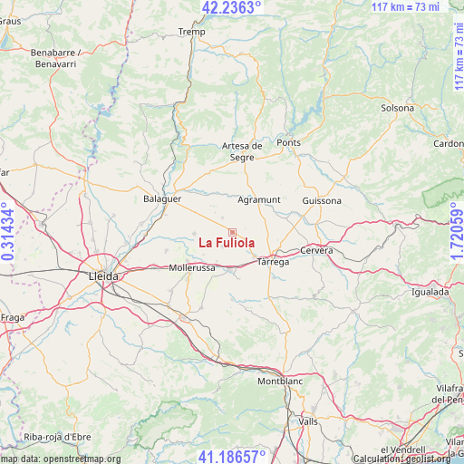
La Fuliola GPS coordinates[2]
41° 42' 48.888" North, 1° 1' 2.856" East
| Map corner | latitude | longitude |
|---|---|---|
| Upper-left | 42.2363°, | 0.31434° |
| Center: | 41.71358°, | 1.01746° |
| Lower-right: | 41.18657°, | 1.72059° |
| Map W x H: | 116.7×116.7 km | = 72.5×72.5mi |
| max Lat: | 43.74134° ⇑33.7% North |
| La Fuliola: | 41.71358° |
| min Lat: | ⇓66.3% South 27.64134° |
| min Long | La Fuliola | max Long |
| -18.00367° | 1.01746° | 4.2899° |
| W 90.6%⇐ | ⇒9.4% E |
Elevation
Elevation of La Fuliola is 278 m = 912 ft, and this is 320 m = 1050 ft below average elevation for this country.
| Max E: |
1682 m = 5518 ft | 76.5% |
| Avg. | 598 m = 1962 ft | |
| La Fuliola | 278 m = 912 ft | |
Min E: |
0 m = 0 ft | 23.5% |
See also: Spain elevation on elevation.city.
Geographical zone
La Fuliola is located in North temperate zone (between Tropic of Cancer and the Arctic Circle). Distance of this Northern Tropic circle is 2032.2 km =1262.8 mi to South.| Distance of | km | miles | from La Fuliola |
|---|---|---|---|
| North Pole | 5368.9 | 3336.1 | to North |
| Arctic Circle | 2763.1 | 1716.9 | to North |
| Tropic Cancer | 2032.2 | 1262.8 | to South |
| Equator | 4638.1 | 2882 | to South |


Nearby cities:
15 places around La Fuliola: (largest is in red/bold)
• Agramunt
10.5 km =6.5 mi,  38°
38°
• Anglesola
8.4 km =5.2 mi,  139°
139°
• Barbens
3.9 km =2.4 mi,  180°
180°
• Bellcaire d'Urgell
9.3 km =5.8 mi,  295°
295°
• Bellpuig
9.8 km =6.1 mi, 182°
• Castellnou de Seana
8.3 km =5.2 mi,  207°
207°
• Castellserà
4.3 km =2.7 mi,  340°
340°
• Golmés
11.4 km =7.1 mi,  218°
218°
• Ivars d'Urgell
4.5 km =2.8 mi, 214°
• Linyola
8.5 km =5.3 mi,  259°
259°
• Montgai
10.5 km =6.5 mi, 336°
• Penelles
5.8 km =3.6 mi,  313°
313°
• Preixens
9.6 km =6 mi,  16°
16°
• Tornabous
3.3 km =2.1 mi,  114°
114°
• Vilanova de Bellpuig
11.9 km =7.4 mi,  201°
201°
Sources, notices
• [Note1] Compared only with cities in Spain existing in our database
• [Src1] Map data: © OpenStreetMap contributors (CC-BY-SA)
• [Src2] Other city data from geonames.org with taken over terms of usage.
• [Src3] Geographical zone / Annual Mean Temperature by Robert A. Rohde @ Wikipedia
