Bayubas de Abajo geodata
Bayubas de Abajo (Castille and León) is a seat of a third-order administrative division; located in Spain in Europe/Madrid (GMT+2) time zone. With population of 237 people, there are 4822 cities with bigger population in this country. Compared to other cities in Spain, 61.5% of cities are located further ↓South; 56% of cities are located further ←West and 82.9% of cities have lower elevation than Bayubas de Abajo. Note1
Administrative division(s):
- Level 1: Castille and León
- Level 2: Provincia de Soria
- Level 3: Bayubas de Abajo


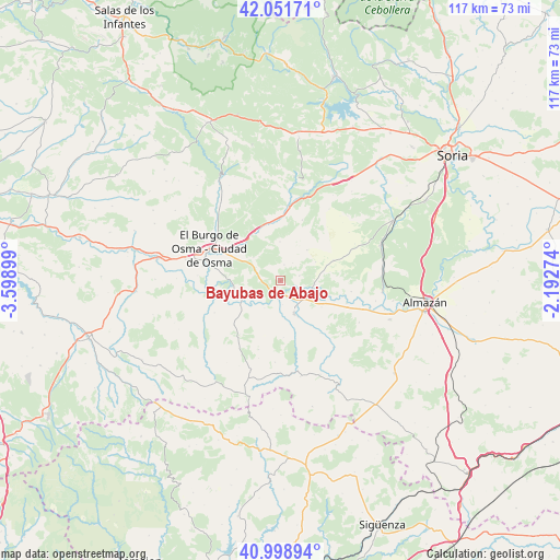
Bayubas de Abajo GPS coordinates[2]
41° 31' 38.892" North, 2° 53' 45.096" West
| Map corner | latitude | longitude |
|---|---|---|
| Upper-left | 42.05171°, | -3.59899° |
| Center: | 41.52747°, | -2.89586° |
| Lower-right: | 40.99894°, | -2.19274° |
| Map W x H: | 117.1×117.1 km | = 72.8×72.8mi |
| max Lat: | 43.74134° ⇑38.5% North |
| Bayubas de Abajo: | 41.52747° |
| min Lat: | ⇓61.5% South 27.64134° |
| min Long | Bayubas de Abaj | max Long |
| -18.00367° | -2.89586° | 4.2899° |
| W 56%⇐ | ⇒44% E |
Elevation
Elevation of Bayubas de Abajo is 927 m = 3041 ft, and this is 329 m = 1079 ft above average elevation for this country.
| Max E: |
1682 m = 5518 ft | 17.1% |
| Bayubas de Abajo | 927 m 3041 ft | |
| Avg. | 598 m = 1962 ft | |
Min E: |
0 m = 0 ft | 82.9% |
See also: Spain elevation on elevation.city.
Geographical zone
Bayubas de Abajo is located in North temperate zone (between Tropic of Cancer and the Arctic Circle). Distance of this Northern Tropic circle is 2011.5 km =1249.9 mi to South.| Distance of | km | miles | from Bayubas de Abajo |
|---|---|---|---|
| North Pole | 5389.6 | 3348.9 | to North |
| Arctic Circle | 2783.8 | 1729.8 | to North |
| Tropic Cancer | 2011.5 | 1249.9 | to South |
| Equator | 4617.4 | 2869.1 | to South |


Nearby cities:
15 places around Bayubas de Abajo: (largest is in red/bold)
• Bayubas de Arriba
3.4 km =2.1 mi,  12°
12°
• Berlanga de Duero
7.5 km =4.7 mi,  157°
157°
• Blacos
17.3 km =10.7 mi, 10°
• Caltojar
17.7 km =11 mi,  141°
141°
• Centenera de Andaluz
15 km =9.3 mi,  98°
98°
• El Burgo de Osma
15.5 km =9.6 mi,  294°
294°
• Fuentepinilla
11.9 km =7.4 mi,  68°
68°
• Gormaz
9.9 km =6.2 mi,  246°
246°
• Quintanas de Gormaz
7 km =4.3 mi, 253°
• Recuerda
10.1 km =6.3 mi,  234°
234°
• Tajueco
4.1 km =2.5 mi,  75°
75°
• Torreblacos
15.8 km =9.8 mi, 5°
• Valdenebro
7.5 km =4.7 mi,  310°
310°
• Valderrodilla
8.4 km =5.2 mi,  61°
61°
• Villanueva de Gormaz
15.4 km =9.6 mi,  244°
244°
Sources, notices
• [Note1] Compared only with cities in Spain existing in our database
• [Src1] Map data: © OpenStreetMap contributors (CC-BY-SA)
• [Src2] Other city data from geonames.org with taken over terms of usage.
• [Src3] Geographical zone / Annual Mean Temperature by Robert A. Rohde @ Wikipedia
