Besalú geodata
Besalú (Catalonia) is a seat of a third-order administrative division; located in Spain in Europe/Madrid (GMT+2) time zone. With population of 2,213 people, there are 2042 cities with bigger population in this country. Compared to other cities in Spain, 79.2% of cities are located further ↓South; 97.2% of cities are located further ←West and 83.7% of cities have higher elevation than Besalú. Note1


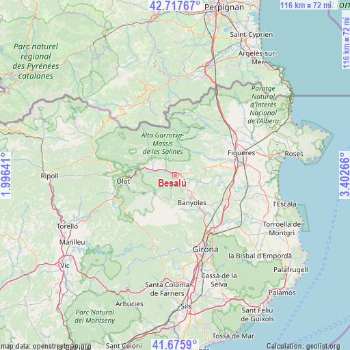
Besalú GPS coordinates[2]
42° 11' 56.148" North, 2° 41' 58.308" East
| Map corner | latitude | longitude |
|---|---|---|
| Upper-left | 42.71767°, | 1.99641° |
| Center: | 42.19893°, | 2.69953° |
| Lower-right: | 41.6759°, | 3.40266° |
| Map W x H: | 115.8×115.8 km | = 72×72mi |
| max Lat: | 43.74134° ⇑20.8% North |
| Besalú: | 42.19893° |
| min Lat: | ⇓79.2% South 27.64134° |
| min Long | Besalú | max Long |
| -18.00367° | 2.69953° | 4.2899° |
| W 97.2%⇐ | ⇒2.8% E |
Elevation
Elevation of Besalú is 159 m = 522 ft, and this is 439 m = 1440 ft below average elevation for this country.
| Max E: |
1682 m = 5518 ft | 83.7% |
| Avg. | 598 m = 1962 ft | |
| Besalú | 159 m = 522 ft | |
Min E: |
0 m = 0 ft | 16.3% |
See also: Spain elevation on elevation.city.
Geographical zone
Besalú is located in North temperate zone (between Tropic of Cancer and the Arctic Circle). Distance of this Northern Tropic circle is 2086.2 km =1296.3 mi to South.| Distance of | km | miles | from Besalú |
|---|---|---|---|
| North Pole | 5315 | 3302.6 | to North |
| Arctic Circle | 2709.1 | 1683.4 | to North |
| Tropic Cancer | 2086.2 | 1296.3 | to South |
| Equator | 4692.1 | 2915.5 | to South |


Nearby cities:
15 places around Besalú: (largest is in red/bold)
• Argelaguer
5.1 km =3.2 mi,  291°
291°
• Banyoles
10.7 km =6.6 mi,  148°
148°
• Beuda
4.3 km =2.7 mi,  10°
10°
• Cabanelles
10.5 km =6.5 mi,  70°
70°
• Crespià
8.5 km =5.3 mi,  101°
101°
• Esponellà
9 km =5.6 mi,  113°
113°
• Lladó
10.9 km =6.8 mi,  60°
60°
• Mieres
9.9 km =6.2 mi,  210°
210°
• Montagut
9.2 km =5.7 mi, 292°
• Porqueres
9.8 km =6.1 mi,  159°
159°
• Sales de Llierca
5.6 km =3.5 mi,  313°
313°
• Sant Ferriol
2.7 km =1.7 mi,  272°
272°
• Sant Jaume de Llierca
7.1 km =4.4 mi, 286°
• Sant Miquel de Campmajor
7.4 km =4.6 mi,  190°
190°
• Tortellà
6.7 km =4.2 mi, 305°
Sources, notices
• [Note1] Compared only with cities in Spain existing in our database
• [Src1] Map data: © OpenStreetMap contributors (CC-BY-SA)
• [Src2] Other city data from geonames.org with taken over terms of usage.
• [Src3] Geographical zone / Annual Mean Temperature by Robert A. Rohde @ Wikipedia
