Balconchán geodata
Balconchán (Aragon) is a seat of a third-order administrative division; located in Spain in Europe/Madrid (GMT+2) time zone. With population of 15 people, there are 6744 cities with bigger population in this country. Compared to other cities in Spain, 50.7% of cities are located further ↓South; 73.3% of cities are located further ←West and 78.5% of cities have lower elevation than Balconchán. Note1


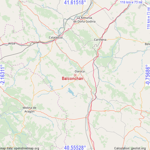
Balconchán GPS coordinates[2]
41° 5' 14.532" North, 1° 27' 35.928" West
| Map corner | latitude | longitude |
|---|---|---|
| Upper-left | 41.61518°, | -2.16311° |
| Center: | 41.08737°, | -1.45998° |
| Lower-right: | 40.55528°, | -0.75686° |
| Map W x H: | 117.8×117.8 km | = 73.2×73.2mi |
| max Lat: | 43.74134° ⇑49.3% North |
| Balconchán: | 41.08737° |
| min Lat: | ⇓50.7% South 27.64134° |
| min Long | Balconchán | max Long |
| -18.00367° | -1.45998° | 4.2899° |
| W 73.3%⇐ | ⇒26.7% E |
Elevation
Elevation of Balconchán is 885 m = 2904 ft, and this is 287 m = 942 ft above average elevation for this country.
| Max E: |
1682 m = 5518 ft | 21.5% |
| Balconchán | 885 m 2904 ft | |
| Avg. | 598 m = 1962 ft | |
Min E: |
0 m = 0 ft | 78.5% |
See also: Spain elevation on elevation.city.
Geographical zone
Balconchán is located in North temperate zone (between Tropic of Cancer and the Arctic Circle). Distance of this Northern Tropic circle is 1962.6 km =1219.5 mi to South.| Distance of | km | miles | from Balconchán |
|---|---|---|---|
| North Pole | 5438.6 | 3379.4 | to North |
| Arctic Circle | 2832.7 | 1760.2 | to North |
| Tropic Cancer | 1962.6 | 1219.5 | to South |
| Equator | 4568.5 | 2838.7 | to South |


Nearby cities:
15 places around Balconchán: (largest is in red/bold)
• Anento
10.8 km =6.7 mi,  100°
100°
• Báguena
10 km =6.2 mi,  120°
120°
• Castejón de Tornos
10.4 km =6.5 mi,  165°
165°
• Daroca
4.8 km =3 mi,  51°
51°
• Manchones
7 km =4.3 mi,  355°
355°
• Murero
8.3 km =5.2 mi,  346°
346°
• Nombrevilla
8.7 km =5.4 mi,  75°
75°
• Orcajo
3.5 km =2.2 mi,  315°
315°
• Retascón
8.9 km =5.5 mi, 45°
• San Martín del Río
6.5 km =4 mi,  111°
111°
• Santed
7.5 km =4.7 mi,  214°
214°
• Used
9.1 km =5.7 mi,  247°
247°
• Val de San Martín
3.4 km =2.1 mi,  164°
164°
• Valdehorna
3.4 km =2.1 mi, 118°
• Villanueva de Jiloca
6 km =3.7 mi, 101°
Sources, notices
• [Note1] Compared only with cities in Spain existing in our database
• [Src1] Map data: © OpenStreetMap contributors (CC-BY-SA)
• [Src2] Other city data from geonames.org with taken over terms of usage.
• [Src3] Geographical zone / Annual Mean Temperature by Robert A. Rohde @ Wikipedia
