Fuentelcésped geodata
Fuentelcésped (Castille and León) is a seat of a third-order administrative division; located in Spain in Europe/Madrid (GMT+2) time zone. With population of 205 people, there are 5010 cities with bigger population in this country. Compared to other cities in Spain, 63.2% of cities are located further ↓South; 54.4% of cities are located further →East and 78.9% of cities have lower elevation than Fuentelcésped. Note1
Administrative division(s):
- Level 1: Castille and León
- Level 2: Provincia de Burgos
- Level 3: Fuentelcésped


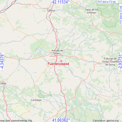
Fuentelcésped GPS coordinates[2]
41° 35' 29.832" North, 3° 38' 26.304" West
| Map corner | latitude | longitude |
|---|---|---|
| Upper-left | 42.11534°, | -4.34376° |
| Center: | 41.59162°, | -3.64064° |
| Lower-right: | 41.06362°, | -2.93751° |
| Map W x H: | 116.9×116.9 km | = 72.6×72.6mi |
| max Lat: | 43.74134° ⇑36.8% North |
| Fuentelcésped: | 41.59162° |
| min Lat: | ⇓63.2% South 27.64134° |
| min Long | Fuentelcésped | max Long |
| -18.00367° | -3.64064° | 4.2899° |
| W 45.6%⇐ | ⇒54.4% E |
Elevation
Elevation of Fuentelcésped is 888 m = 2913 ft, and this is 290 m = 951 ft above average elevation for this country.
| Max E: |
1682 m = 5518 ft | 21.1% |
| Fuentelcésped | 888 m 2913 ft | |
| Avg. | 598 m = 1962 ft | |
Min E: |
0 m = 0 ft | 78.9% |
See also: Spain elevation on elevation.city.
Geographical zone
Fuentelcésped is located in North temperate zone (between Tropic of Cancer and the Arctic Circle). Distance of this Northern Tropic circle is 2018.6 km =1254.3 mi to South.| Distance of | km | miles | from Fuentelcésped |
|---|---|---|---|
| North Pole | 5382.5 | 3344.5 | to North |
| Arctic Circle | 2776.6 | 1725.3 | to North |
| Tropic Cancer | 2018.6 | 1254.3 | to South |
| Equator | 4624.6 | 2873.6 | to South |


Nearby cities:
15 places around Fuentelcésped: (largest is in red/bold)
• Aranda de Duero
9.6 km =6 mi,  335°
335°
• Campillo de Aranda
7.7 km =4.8 mi,  285°
285°
• Castillejo de Robledo
12.5 km =7.8 mi,  107°
107°
• Fresnillo de las Dueñas
6.2 km =3.9 mi,  356°
356°
• Fuentenebro
11.8 km =7.3 mi,  233°
233°
• Fuentespina
5.7 km =3.5 mi,  319°
319°
• Honrubia de la Cuesta
10.5 km =6.5 mi,  210°
210°
• Milagros
5.2 km =3.2 mi,  249°
249°
• Montejo de la Vega de la Serrezuela
4.7 km =2.9 mi,  193°
193°
• Pardilla
7.3 km =4.5 mi, 232°
• Santa Cruz de la Salceda
4 km =2.5 mi,  83°
83°
• Torregalindo
9.3 km =5.8 mi,  264°
264°
• Vadocondes
7.7 km =4.8 mi,  46°
46°
• Valdevacas de Montejo
7.9 km =4.9 mi,  177°
177°
• Villaverde de Montejo
7.8 km =4.8 mi, 188°
Sources, notices
• [Note1] Compared only with cities in Spain existing in our database
• [Src1] Map data: © OpenStreetMap contributors (CC-BY-SA)
• [Src2] Other city data from geonames.org with taken over terms of usage.
• [Src3] Geographical zone / Annual Mean Temperature by Robert A. Rohde @ Wikipedia
