Ansó geodata
Ansó (Aragon) is a seat of a third-order administrative division; located in Spain in Europe/Madrid (GMT+2) time zone. With population of 519 people, there are 3818 cities with bigger population in this country. Compared to other cities in Spain, 92.1% of cities are located further ↓South; 78.5% of cities are located further ←West and 75.8% of cities have lower elevation than Ansó. Note1


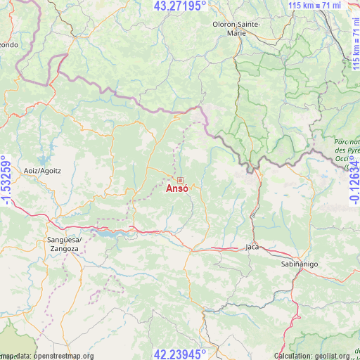
Ansó GPS coordinates[2]
42° 45' 28.26" North, 0° 49' 46.092" West
| Map corner | latitude | longitude |
|---|---|---|
| Upper-left | 43.27195°, | -1.53259° |
| Center: | 42.75785°, | -0.82947° |
| Lower-right: | 42.23945°, | -0.12634° |
| Map W x H: | 114.8×114.8 km | = 71.3×71.3mi |
| max Lat: | 43.74134° ⇑7.9% North |
| Ansó: | 42.75785° |
| min Lat: | ⇓92.1% South 27.64134° |
| min Long | Ansó | max Long |
| -18.00367° | -0.82947° | 4.2899° |
| W 78.5%⇐ | ⇒21.5% E |
Elevation
Elevation of Ansó is 859 m = 2818 ft, and this is 261 m = 856 ft above average elevation for this country.
| Max E: |
1682 m = 5518 ft | 24.2% |
| Ansó | 859 m 2818 ft | |
| Avg. | 598 m = 1962 ft | |
Min E: |
0 m = 0 ft | 75.8% |
See also: Spain elevation on elevation.city.
Geographical zone
Ansó is located in North temperate zone (between Tropic of Cancer and the Arctic Circle). Distance of this Northern Tropic circle is 2148.3 km =1334.9 mi to South.| Distance of | km | miles | from Ansó |
|---|---|---|---|
| North Pole | 5252.8 | 3263.9 | to North |
| Arctic Circle | 2646.9 | 1644.7 | to North |
| Tropic Cancer | 2148.3 | 1334.9 | to South |
| Equator | 4754.2 | 2954.1 | to South |


Nearby cities:
15 places around Ansó: (largest is in red/bold)
• Aragüés del Puerto
14.2 km =8.8 mi,  113°
113°
• Artieda
23 km =14.3 mi,  213°
213°
• Bagüés
25.1 km =15.6 mi,  202°
202°
• Borau
22.6 km =14 mi,  119°
119°
• Castillonuevo
18.5 km =11.5 mi,  243°
243°
• Echo
6.8 km =4.2 mi, 108°
• Fago
5 km =3.1 mi, 238°
• Garde
8.6 km =5.3 mi,  294°
294°
• Jasa
15.1 km =9.4 mi, 117°
• Mianos
21.7 km =13.5 mi, 208°
• Navascués
23.9 km =14.9 mi,  259°
259°
• Puente la Reina de Jaca
22.4 km =13.9 mi,  171°
171°
• Salvatierra de Esca
17.3 km =10.7 mi, 235°
• Sigüés
20.6 km =12.8 mi,  226°
226°
• Urzainqui
12.5 km =7.8 mi,  310°
310°
Sources, notices
• [Note1] Compared only with cities in Spain existing in our database
• [Src1] Map data: © OpenStreetMap contributors (CC-BY-SA)
• [Src2] Other city data from geonames.org with taken over terms of usage.
• [Src3] Geographical zone / Annual Mean Temperature by Robert A. Rohde @ Wikipedia
