Tafalla geodata
Tafalla (Navarre) is a seat of a third-order administrative division; located in Spain in Europe/Madrid (GMT+2) time zone. With population of 11,394 people, there are 774 cities with bigger population in this country. Compared to other cities in Spain, 87.9% of cities are located further ↓South; 71% of cities are located further ←West and 67.6% of cities have higher elevation than Tafalla. Note1


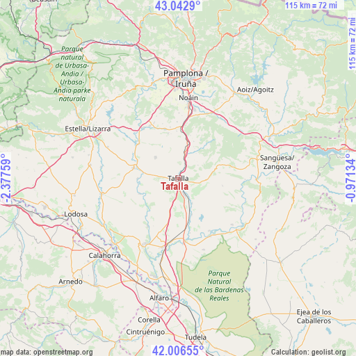
Tafalla GPS coordinates[2]
42° 31' 36.732" North, 1° 40' 28.056" West
| Map corner | latitude | longitude |
|---|---|---|
| Upper-left | 43.0429°, | -2.37759° |
| Center: | 42.52687°, | -1.67446° |
| Lower-right: | 42.00655°, | -0.97134° |
| Map W x H: | 115.2×115.2 km | = 71.6×71.6mi |
| max Lat: | 43.74134° ⇑12.1% North |
| Tafalla: | 42.52687° |
| min Lat: | ⇓87.9% South 27.64134° |
| min Long | Tafalla | max Long |
| -18.00367° | -1.67446° | 4.2899° |
| W 71%⇐ | ⇒29% E |
Elevation
Elevation of Tafalla is 424 m = 1391 ft, and this is 174 m = 571 ft below average elevation for this country.
| Max E: |
1682 m = 5518 ft | 67.6% |
| Avg. | 598 m = 1962 ft | |
| Tafalla | 424 m = 1391 ft | |
Min E: |
0 m = 0 ft | 32.4% |
See also: Spain elevation on elevation.city.
Geographical zone
Tafalla is located in North temperate zone (between Tropic of Cancer and the Arctic Circle). Distance of this Northern Tropic circle is 2122.6 km =1318.9 mi to South.| Distance of | km | miles | from Tafalla |
|---|---|---|---|
| North Pole | 5278.5 | 3279.9 | to North |
| Arctic Circle | 2672.6 | 1660.7 | to North |
| Tropic Cancer | 2122.6 | 1318.9 | to South |
| Equator | 4728.5 | 2938.2 | to South |


Nearby cities:
15 places around Tafalla: (largest is in red/bold)
• Artajona
10.1 km =6.3 mi,  312°
312°
• Barásoain
8.8 km =5.5 mi,  15°
15°
• Beire
9.2 km =5.7 mi,  151°
151°
• Berbinzana
13.1 km =8.1 mi,  270°
270°
• Garínoain
8.5 km =5.3 mi, 16°
• Miranda de Arga
13.5 km =8.4 mi,  248°
248°
• Olite
5.6 km =3.5 mi,  160°
160°
• Olóriz
13.1 km =8.1 mi, 22°
• Orísoain
10.1 km =6.3 mi,  34°
34°
• Pitillas
12.5 km =7.8 mi, 159°
• Pueyo
4.8 km =3 mi, 26°
• San Martín de Unx
9.3 km =5.8 mi,  91°
91°
• Tirapu
14.7 km =9.1 mi,  350°
350°
• Ujué
14.6 km =9.1 mi,  101°
101°
• Unzué
14.5 km =9 mi, 15°
Sources, notices
• [Note1] Compared only with cities in Spain existing in our database
• [Src1] Map data: © OpenStreetMap contributors (CC-BY-SA)
• [Src2] Other city data from geonames.org with taken over terms of usage.
• [Src3] Geographical zone / Annual Mean Temperature by Robert A. Rohde @ Wikipedia
