Alfarràs geodata
Alfarràs (Catalonia) is a populated place; located in Spain in Europe/Madrid (GMT+2) time zone. With population of 3,335 people, there are 1628 cities with bigger population in this country. Compared to other cities in Spain, 68.9% of cities are located further ↓South; 89.3% of cities are located further ←West and 77.4% of cities have higher elevation than Alfarràs. Note1


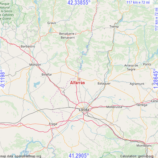
Alfarràs GPS coordinates[2]
41° 49' 0.012" North, 0° 34' 59.988" East
| Map corner | latitude | longitude |
|---|---|---|
| Upper-left | 42.33855°, | -0.1198° |
| Center: | 41.81667°, | 0.58333° |
| Lower-right: | 41.2905°, | 1.28645° |
| Map W x H: | 116.5×116.5 km | = 72.4×72.4mi |
| max Lat: | 43.74134° ⇑31.1% North |
| Alfarràs: | 41.81667° |
| min Lat: | ⇓68.9% South 27.64134° |
| min Long | Alfarràs | max Long |
| -18.00367° | 0.58333° | 4.2899° |
| W 89.3%⇐ | ⇒10.7% E |
Elevation
Elevation of Alfarràs is 264 m = 866 ft, and this is 334 m = 1096 ft below average elevation for this country.
| Max E: |
1682 m = 5518 ft | 77.4% |
| Avg. | 598 m = 1962 ft | |
| Alfarràs | 264 m = 866 ft | |
Min E: |
0 m = 0 ft | 22.6% |
See also: Spain elevation on elevation.city.
Geographical zone
Alfarràs is located in North temperate zone (between Tropic of Cancer and the Arctic Circle). Distance of this Northern Tropic circle is 2043.7 km =1269.9 mi to South.| Distance of | km | miles | from Alfarràs |
|---|---|---|---|
| North Pole | 5357.5 | 3329 | to North |
| Arctic Circle | 2751.6 | 1709.8 | to North |
| Tropic Cancer | 2043.7 | 1269.9 | to South |
| Equator | 4649.6 | 2889.1 | to South |


Nearby cities:
15 places around Alfarràs: (largest is in red/bold)
• Albelda
11.6 km =7.2 mi,  297°
297°
• Albesa
9.5 km =5.9 mi,  138°
138°
• Algerri
4.4 km =2.7 mi,  92°
92°
• Alguaire
8.9 km =5.5 mi,  179°
179°
• Almacelles
15.3 km =9.5 mi,  232°
232°
• Almenar
2.6 km =1.6 mi,  208°
208°
• Camporrells
16.6 km =10.3 mi,  341°
341°
• Castelló de Farfanya
12.4 km =7.7 mi, 90°
• Menàrguens
16.6 km =10.3 mi,  123°
123°
• Os de Balaguer
13 km =8.1 mi,  61°
61°
• Tamarit de Llitera / Tamarite de Litera
14.6 km =9.1 mi,  293°
293°
• Torrefarrera
16.1 km =10 mi,  173°
173°
• Vilanova de Segrià
11.5 km =7.1 mi, 166°
• el Campell / Alcampell
16 km =9.9 mi,  308°
308°
• el Torricó / Altorricon
14.1 km =8.8 mi,  263°
263°
Sources, notices
• [Note1] Compared only with cities in Spain existing in our database
• [Src1] Map data: © OpenStreetMap contributors (CC-BY-SA)
• [Src2] Other city data from geonames.org with taken over terms of usage.
• [Src3] Geographical zone / Annual Mean Temperature by Robert A. Rohde @ Wikipedia
