Gómara geodata
Gómara (Castille and León) is a seat of a third-order administrative division; located in Spain in Europe/Madrid (GMT+2) time zone. With population of 416 people, there are 4087 cities with bigger population in this country. Compared to other cities in Spain, 64.1% of cities are located further ↓South; 64.4% of cities are located further ←West and 91.3% of cities have lower elevation than Gómara. Note1


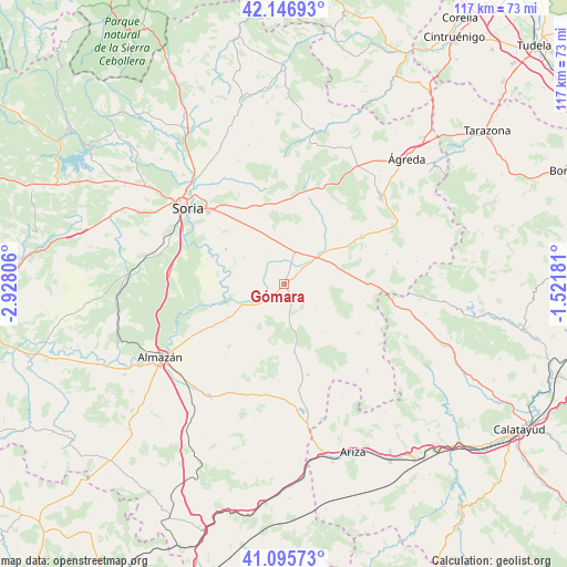
Gómara GPS coordinates[2]
41° 37' 24.492" North, 2° 13' 29.748" West
| Map corner | latitude | longitude |
|---|---|---|
| Upper-left | 42.14693°, | -2.92806° |
| Center: | 41.62347°, | -2.22493° |
| Lower-right: | 41.09573°, | -1.52181° |
| Map W x H: | 116.9×116.9 km | = 72.6×72.6mi |
| max Lat: | 43.74134° ⇑35.9% North |
| Gómara: | 41.62347° |
| min Lat: | ⇓64.1% South 27.64134° |
| min Long | Gómara | max Long |
| -18.00367° | -2.22493° | 4.2899° |
| W 64.4%⇐ | ⇒35.6% E |
Elevation
Elevation of Gómara is 1052 m = 3451 ft, and this is 454 m = 1490 ft above average elevation for this country.
| Max E: |
1682 m = 5518 ft | 8.7% |
| Gómara | 1052 m 3451 ft | |
| Avg. | 598 m = 1962 ft | |
Min E: |
0 m = 0 ft | 91.3% |
See also: Spain elevation on elevation.city.
Geographical zone
Gómara is located in North temperate zone (between Tropic of Cancer and the Arctic Circle). Distance of this Northern Tropic circle is 2022.2 km =1256.5 mi to South.| Distance of | km | miles | from Gómara |
|---|---|---|---|
| North Pole | 5379 | 3342.4 | to North |
| Arctic Circle | 2773.1 | 1723.1 | to North |
| Tropic Cancer | 2022.2 | 1256.5 | to South |
| Equator | 4628.1 | 2875.8 | to South |


Nearby cities:
15 places around Gómara: (largest is in red/bold)
• Aldealafuente
9.9 km =6.2 mi,  302°
302°
• Aliud
4.1 km =2.5 mi,  325°
325°
• Almazul
8.6 km =5.3 mi,  130°
130°
• Almenar de Soria
6.8 km =4.2 mi,  17°
17°
• Bliecos
11.3 km =7 mi,  199°
199°
• Borjabad
14.2 km =8.8 mi,  236°
236°
• Buberos
3.7 km =2.3 mi,  44°
44°
• Cabrejas del Campo
7.4 km =4.6 mi, 329°
• Candilichera
11 km =6.8 mi,  324°
324°
• Portillo de Soria
8.7 km =5.4 mi,  81°
81°
• Tajahuerce
14.3 km =8.9 mi,  25°
25°
• Tejado
5.2 km =3.2 mi,  222°
222°
• Torrubia de Soria
11.1 km =6.9 mi,  85°
85°
• Velilla de los Ajos
15 km =9.3 mi,  189°
189°
• Villaseca de Arciel
5.3 km =3.3 mi, 88°
Sources, notices
• [Note1] Compared only with cities in Spain existing in our database
• [Src1] Map data: © OpenStreetMap contributors (CC-BY-SA)
• [Src2] Other city data from geonames.org with taken over terms of usage.
• [Src3] Geographical zone / Annual Mean Temperature by Robert A. Rohde @ Wikipedia
