Ourense geodata
Ourense (Galicia) is a seat of a second-order administrative division; located in Spain in Europe/Madrid (GMT+2) time zone. With population of 107,742 people, there are 83 cities with bigger population in this country. Compared to other cities in Spain, 82.9% of cities are located further ↓South; 96.1% of cities are located further →East and 84.6% of cities have higher elevation than Ourense. Note1


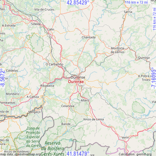
Ourense GPS coordinates[2]
42° 20' 12.084" North, 7° 51' 50.652" West
| Map corner | latitude | longitude |
|---|---|---|
| Upper-left | 42.85429°, | -8.5672° |
| Center: | 42.33669°, | -7.86407° |
| Lower-right: | 41.81479°, | -7.16095° |
| Map W x H: | 115.6×115.6 km | = 71.8×71.8mi |
| max Lat: | 43.74134° ⇑17.1% North |
| Ourense: | 42.33669° |
| min Lat: | ⇓82.9% South 27.64134° |
| min Long | Ourense | max Long |
| -18.00367° | -7.86407° | 4.2899° |
| W 3.9%⇐ | ⇒96.1% E |
Elevation
Elevation of Ourense is 146 m = 479 ft, and this is 452 m = 1483 ft below average elevation for this country.
| Max E: |
1682 m = 5518 ft | 84.6% |
| Avg. | 598 m = 1962 ft | |
| Ourense | 146 m = 479 ft | |
Min E: |
0 m = 0 ft | 15.4% |
See also: Ourense elevation on elevation.city.
Geographical zone
Ourense is located in North temperate zone (between Tropic of Cancer and the Arctic Circle). Distance of this Northern Tropic circle is 2101.5 km =1305.8 mi to South.| Distance of | km | miles | from Ourense |
|---|---|---|---|
| North Pole | 5299.7 | 3293.1 | to North |
| Arctic Circle | 2693.8 | 1673.8 | to North |
| Tropic Cancer | 2101.5 | 1305.8 | to South |
| Equator | 4707.4 | 2925 | to South |


Nearby cities:
15 places around Ourense: (largest is in red/bold)
• Allariz
17.1 km =10.6 mi,  162°
162°
• Amoeiro
11.4 km =7.1 mi,  321°
321°
• Castrelo de Miño
17.2 km =10.7 mi,  255°
255°
• Coles
7.5 km =4.7 mi,  19°
19°
• Esgos
13.8 km =8.6 mi,  95°
95°
• Luintra
13.9 km =8.6 mi,  54°
54°
• Maside
15.6 km =9.7 mi,  301°
301°
• Nogueira de Ramuín
13 km =8.1 mi, 46°
• Pereiro de Aguiar
5.3 km =3.3 mi,  79°
79°
• Punxín
12.6 km =7.8 mi,  287°
287°
• San Amaro
17.7 km =11 mi,  283°
283°
• Taboadela
10.9 km =6.8 mi, 163°
• Toén
7.7 km =4.8 mi,  254°
254°
• Vilamarín
14.4 km =8.9 mi,  351°
351°
• Vilarnaz
7.1 km =4.4 mi,  0°
0°
Sources, notices
• [Note1] Compared only with cities in Spain existing in our database
• [Src1] Map data: © OpenStreetMap contributors (CC-BY-SA)
• [Src2] Other city data from geonames.org with taken over terms of usage.
• [Src3] Geographical zone / Annual Mean Temperature by Robert A. Rohde @ Wikipedia
