Maceda geodata
Maceda (Galicia) is a seat of a third-order administrative division; located in Spain in Europe/Madrid (GMT+2) time zone. With population of 3,232 people, there are 1650 cities with bigger population in this country. Compared to other cities in Spain, 81.1% of cities are located further ↓South; 95.7% of cities are located further →East and 55.5% of cities have higher elevation than Maceda. Note1


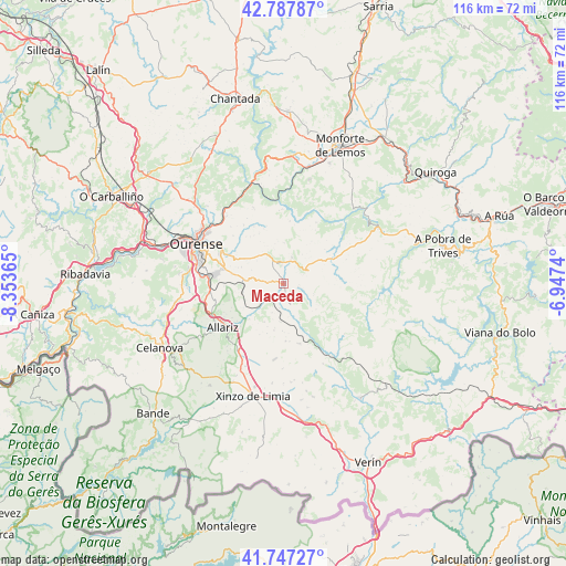
Maceda GPS coordinates[2]
42° 16' 10.992" North, 7° 39' 1.872" West
| Map corner | latitude | longitude |
|---|---|---|
| Upper-left | 42.78787°, | -8.35365° |
| Center: | 42.26972°, | -7.65052° |
| Lower-right: | 41.74727°, | -6.9474° |
| Map W x H: | 115.7×115.7 km | = 71.9×71.9mi |
| max Lat: | 43.74134° ⇑18.9% North |
| Maceda: | 42.26972° |
| min Lat: | ⇓81.1% South 27.64134° |
| min Long | Maceda | max Long |
| -18.00367° | -7.65052° | 4.2899° |
| W 4.3%⇐ | ⇒95.7% E |
Elevation
Elevation of Maceda is 589 m = 1932 ft, and this is 9 m = 30 ft below average elevation for this country.
| Max E: |
1682 m = 5518 ft | 55.5% |
| Avg. | 598 m = 1962 ft | |
| Maceda | 589 m = 1932 ft | |
Min E: |
0 m = 0 ft | 44.5% |
See also: Spain elevation on elevation.city.
Geographical zone
Maceda is located in North temperate zone (between Tropic of Cancer and the Arctic Circle). Distance of this Northern Tropic circle is 2094 km =1301.2 mi to South.| Distance of | km | miles | from Maceda |
|---|---|---|---|
| North Pole | 5307.1 | 3297.7 | to North |
| Arctic Circle | 2701.2 | 1678.4 | to North |
| Tropic Cancer | 2094 | 1301.2 | to South |
| Equator | 4700 | 2920.4 | to South |


Nearby cities:
15 places around Maceda: (largest is in red/bold)
• Allariz
15.3 km =9.5 mi,  234°
234°
• Ambía
10.1 km =6.3 mi, 225°
• Baños de Molgas
3.6 km =2.2 mi,  209°
209°
• Castro Caldelas
21.8 km =13.5 mi,  57°
57°
• Coles
20.9 km =13 mi,  313°
313°
• Esgos
7.3 km =4.5 mi,  328°
328°
• Lobios
18.2 km =11.3 mi,  32°
32°
• Luintra
16.8 km =10.4 mi,  338°
338°
• Montederramo
12.3 km =7.6 mi,  86°
86°
• Nogueira de Ramuín
18.3 km =11.4 mi, 333°
• Ourense
19.1 km =11.9 mi,  292°
292°
• Pereiro de Aguiar
14.9 km =9.3 mi,  304°
304°
• Sarreaus
20.6 km =12.8 mi,  169°
169°
• Sober
21.9 km =13.6 mi,  13°
13°
• Taboadela
14.9 km =9.3 mi,  258°
258°
Sources, notices
• [Note1] Compared only with cities in Spain existing in our database
• [Src1] Map data: © OpenStreetMap contributors (CC-BY-SA)
• [Src2] Other city data from geonames.org with taken over terms of usage.
• [Src3] Geographical zone / Annual Mean Temperature by Robert A. Rohde @ Wikipedia
