La Gangosa Vistasol geodata
La Gangosa Vistasol (Andalusia) is a populated place; located in Spain in Europe/Madrid (GMT+2) time zone. With population of 9,780 people, there are 866 cities with bigger population in this country. Compared to other cities in Spain, 96.8% of cities are located further ↑North; 59.6% of cities are located further ←West and 88.4% of cities have higher elevation than La Gangosa Vistasol. Note1


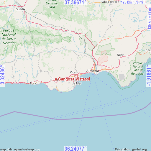
La Gangosa Vistasol GPS coordinates[2]
36° 48' 20.916" North, 2° 37' 18.264" West
| Map corner | latitude | longitude |
|---|---|---|
| Upper-left | 37.36671°, | -3.32486° |
| Center: | 36.80581°, | -2.62174° |
| Lower-right: | 36.24077°, | -1.91861° |
| Map W x H: | 125.2×125.2 km | = 77.8×77.8mi |
| max Lat: | 43.74134° ⇑96.8% North |
| La Gangosa Vistasol: | 36.80581° |
| min Lat: | ⇓3.2% South 27.64134° |
| min Long | La Gangosa Vist | max Long |
| -18.00367° | -2.62174° | 4.2899° |
| W 59.6%⇐ | ⇒40.4% E |
Elevation
Elevation of La Gangosa Vistasol is 88 m = 289 ft, and this is 510 m = 1673 ft below average elevation for this country.
| Max E: |
1682 m = 5518 ft | 88.4% |
| Avg. | 598 m = 1962 ft | |
| La Gangosa Vistasol | 88 m = 289 ft | |
Min E: |
0 m = 0 ft | 11.6% |
See also: Spain elevation on elevation.city.
Geographical zone
La Gangosa Vistasol is located in North temperate zone (between Tropic of Cancer and the Arctic Circle). Distance of this Northern Tropic circle is 1486.5 km =923.7 mi to South.| Distance of | km | miles | from La Gangosa Vistasol |
|---|---|---|---|
| North Pole | 5914.6 | 3675.2 | to North |
| Arctic Circle | 3308.8 | 2056 | to North |
| Tropic Cancer | 1486.5 | 923.7 | to South |
| Equator | 4092.4 | 2542.9 | to South |


Nearby cities:
15 places around La Gangosa Vistasol: (largest is in red/bold)
• Aguadulce
4.5 km =2.8 mi,  78°
78°
• Alhama de Almería
17.5 km =10.9 mi,  15°
15°
• Alicún
17.9 km =11.1 mi,  5°
5°
• Almería
14.9 km =9.3 mi, 76°
• Benahadux
19.6 km =12.2 mi,  47°
47°
• El Ejido
17.5 km =10.9 mi,  259°
259°
• Enix
8.1 km =5 mi, 12°
• Félix
7.8 km =4.8 mi,  335°
335°
• Gádor
20 km =12.4 mi,  35°
35°
• Huécija
18.1 km =11.2 mi,  3°
3°
• Huércal de Almería
18.6 km =11.6 mi,  61°
61°
• Roquetas de Mar
4.7 km =2.9 mi,  172°
172°
• Terque
19.9 km =12.4 mi, 6°
• Viator
19.7 km =12.2 mi, 61°
• Vícar
3.4 km =2.1 mi,  326°
326°
Sources, notices
• [Note1] Compared only with cities in Spain existing in our database
• [Src1] Map data: © OpenStreetMap contributors (CC-BY-SA)
• [Src2] Other city data from geonames.org with taken over terms of usage.
• [Src3] Geographical zone / Annual Mean Temperature by Robert A. Rohde @ Wikipedia
