Benahadux geodata
Benahadux (Andalusia) is a seat of a third-order administrative division; located in Spain in Europe/Madrid (GMT+2) time zone. With population of 3,132 people, there are 1683 cities with bigger population in this country. Compared to other cities in Spain, 95.9% of cities are located further ↑North; 61.5% of cities are located further ←West and 85.7% of cities have higher elevation than Benahadux. Note1


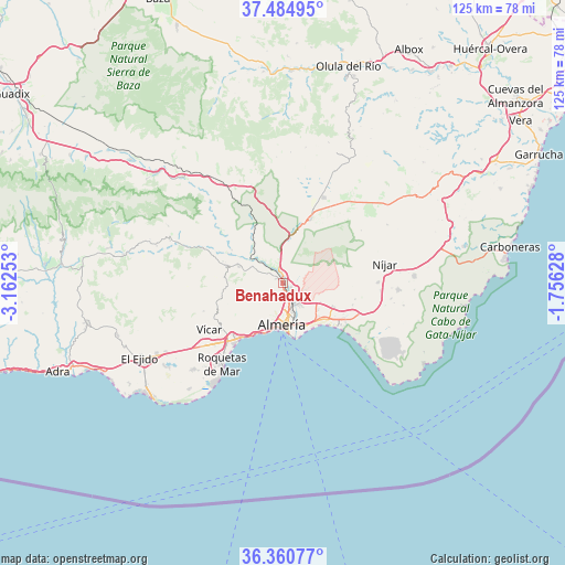
Benahadux GPS coordinates[2]
36° 55' 29.748" North, 2° 27' 33.876" West
| Map corner | latitude | longitude |
|---|---|---|
| Upper-left | 37.48495°, | -3.16253° |
| Center: | 36.92493°, | -2.45941° |
| Lower-right: | 36.36077°, | -1.75628° |
| Map W x H: | 125×125 km | = 77.7×77.7mi |
| max Lat: | 43.74134° ⇑95.9% North |
| Benahadux: | 36.92493° |
| min Lat: | ⇓4.1% South 27.64134° |
| min Long | Benahadux | max Long |
| -18.00367° | -2.45941° | 4.2899° |
| W 61.5%⇐ | ⇒38.5% E |
Elevation
Elevation of Benahadux is 128 m = 420 ft, and this is 470 m = 1542 ft below average elevation for this country.
| Max E: |
1682 m = 5518 ft | 85.7% |
| Avg. | 598 m = 1962 ft | |
| Benahadux | 128 m = 420 ft | |
Min E: |
0 m = 0 ft | 14.3% |
See also: Spain elevation on elevation.city.
Geographical zone
Benahadux is located in North temperate zone (between Tropic of Cancer and the Arctic Circle). Distance of this Northern Tropic circle is 1499.7 km =931.9 mi to South.| Distance of | km | miles | from Benahadux |
|---|---|---|---|
| North Pole | 5901.4 | 3667 | to North |
| Arctic Circle | 3295.5 | 2047.7 | to North |
| Tropic Cancer | 1499.7 | 931.9 | to South |
| Equator | 4105.7 | 2551.2 | to South |


Nearby cities:
15 places around Benahadux: (largest is in red/bold)
• Alhabia
13.4 km =8.3 mi,  302°
302°
• Alhama de Almería
10.3 km =6.4 mi,  290°
290°
• Alicún
13.5 km =8.4 mi, 289°
• Almería
9.7 km =6 mi,  180°
180°
• Alsodux
14.8 km =9.2 mi,  305°
305°
• Costacabana
11.9 km =7.4 mi,  144°
144°
• Enix
13.7 km =8.5 mi,  247°
247°
• Gádor
4.3 km =2.7 mi,  316°
316°
• Huécija
14.2 km =8.8 mi, 289°
• Huércal de Almería
4.8 km =3 mi,  156°
156°
• Pechina
2.2 km =1.4 mi,  115°
115°
• Rioja
2.3 km =1.4 mi,  351°
351°
• Santa Fe de Mondújar
8.5 km =5.3 mi, 310°
• Terque
13.9 km =8.6 mi, 298°
• Viator
4.8 km =3 mi, 143°
Sources, notices
• [Note1] Compared only with cities in Spain existing in our database
• [Src1] Map data: © OpenStreetMap contributors (CC-BY-SA)
• [Src2] Other city data from geonames.org with taken over terms of usage.
• [Src3] Geographical zone / Annual Mean Temperature by Robert A. Rohde @ Wikipedia
