Viator geodata
Viator (Andalusia) is a seat of a third-order administrative division; located in Spain in Europe/Madrid (GMT+2) time zone. With population of 3,945 people, there are 1492 cities with bigger population in this country. Compared to other cities in Spain, 96.1% of cities are located further ↑North; 61.9% of cities are located further ←West and 89.5% of cities have higher elevation than Viator. Note1


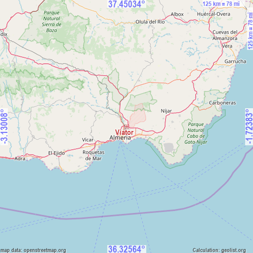
Viator GPS coordinates[2]
36° 53' 24.216" North, 2° 25' 37.02" West
| Map corner | latitude | longitude |
|---|---|---|
| Upper-left | 37.45034°, | -3.13008° |
| Center: | 36.89006°, | -2.42695° |
| Lower-right: | 36.32564°, | -1.72383° |
| Map W x H: | 125.1×125.1 km | = 77.7×77.7mi |
| max Lat: | 43.74134° ⇑96.1% North |
| Viator: | 36.89006° |
| min Lat: | ⇓3.9% South 27.64134° |
| min Long | Viator | max Long |
| -18.00367° | -2.42695° | 4.2899° |
| W 61.9%⇐ | ⇒38.1% E |
Elevation
Elevation of Viator is 75 m = 246 ft, and this is 523 m = 1716 ft below average elevation for this country.
| Max E: |
1682 m = 5518 ft | 89.5% |
| Avg. | 598 m = 1962 ft | |
| Viator | 75 m = 246 ft | |
Min E: |
0 m = 0 ft | 10.5% |
See also: Spain elevation on elevation.city.
Geographical zone
Viator is located in North temperate zone (between Tropic of Cancer and the Arctic Circle). Distance of this Northern Tropic circle is 1495.9 km =929.5 mi to South.| Distance of | km | miles | from Viator |
|---|---|---|---|
| North Pole | 5905.3 | 3669.4 | to North |
| Arctic Circle | 3299.4 | 2050.2 | to North |
| Tropic Cancer | 1495.9 | 929.5 | to South |
| Equator | 4101.8 | 2548.7 | to South |


Nearby cities:
15 places around Viator: (largest is in red/bold)
• Aguadulce
15.5 km =9.6 mi,  236°
236°
• Alhabia
18 km =11.2 mi,  308°
308°
• Alhama de Almería
14.6 km =9.1 mi,  300°
300°
• Alicún
17.7 km =11 mi, 298°
• Almería
6.5 km =4 mi,  206°
206°
• Benahadux
4.8 km =3 mi,  323°
323°
• Costacabana
7.1 km =4.4 mi,  144°
144°
• Enix
15.6 km =9.7 mi,  264°
264°
• Gádor
9.1 km =5.7 mi, 320°
• Huércal de Almería
1.1 km =0.7 mi, 239°
• Pechina
3 km =1.9 mi,  343°
343°
• Retamar
11.7 km =7.3 mi,  122°
122°
• Rioja
6.9 km =4.3 mi,  332°
332°
• Santa Fe de Mondújar
13.2 km =8.2 mi, 315°
• Tabernas
18.1 km =11.2 mi,  10°
10°
Sources, notices
• [Note1] Compared only with cities in Spain existing in our database
• [Src1] Map data: © OpenStreetMap contributors (CC-BY-SA)
• [Src2] Other city data from geonames.org with taken over terms of usage.
• [Src3] Geographical zone / Annual Mean Temperature by Robert A. Rohde @ Wikipedia
