El Ejido geodata
El Ejido (Andalusia) is a populated place; located in Spain in Europe/Madrid (GMT+2) time zone. With population of 84,227 people, there are 104 cities with bigger population in this country. Compared to other cities in Spain, 97% of cities are located further ↑North; 57.2% of cities are located further ←West and 88.8% of cities have higher elevation than El Ejido. Note1


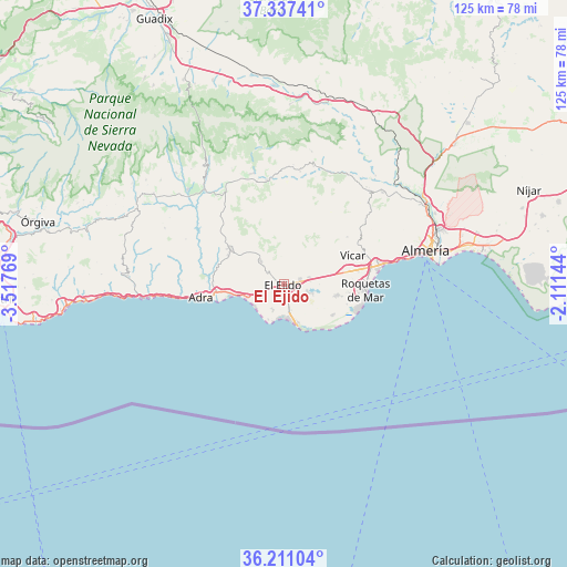
El Ejido GPS coordinates[2]
36° 46' 34.644" North, 2° 48' 52.416" West
| Map corner | latitude | longitude |
|---|---|---|
| Upper-left | 37.33741°, | -3.51769° |
| Center: | 36.77629°, | -2.81456° |
| Lower-right: | 36.21104°, | -2.11144° |
| Map W x H: | 125.2×125.2 km | = 77.8×77.8mi |
| max Lat: | 43.74134° ⇑97% North |
| El Ejido: | 36.77629° |
| min Lat: | ⇓3% South 27.64134° |
| min Long | El Ejido | max Long |
| -18.00367° | -2.81456° | 4.2899° |
| W 57.2%⇐ | ⇒42.8% E |
Elevation
Elevation of El Ejido is 84 m = 276 ft, and this is 514 m = 1686 ft below average elevation for this country.
| Max E: |
1682 m = 5518 ft | 88.8% |
| Avg. | 598 m = 1962 ft | |
| El Ejido | 84 m = 276 ft | |
Min E: |
0 m = 0 ft | 11.2% |
See also: El Ejido elevation on elevation.city.
Geographical zone
El Ejido is located in North temperate zone (between Tropic of Cancer and the Arctic Circle). Distance of this Northern Tropic circle is 1483.2 km =921.6 mi to South.| Distance of | km | miles | from El Ejido |
|---|---|---|---|
| North Pole | 5917.9 | 3677.2 | to North |
| Arctic Circle | 3312 | 2058 | to North |
| Tropic Cancer | 1483.2 | 921.6 | to South |
| Equator | 4089.1 | 2540.8 | to South |


Nearby cities:
15 places around El Ejido: (largest is in red/bold)
• Adra
18.6 km =11.6 mi,  260°
260°
• Aguadulce
22 km =13.7 mi,  78°
78°
• Almócita
25.3 km =15.7 mi,  4°
4°
• Balanegra
9 km =5.6 mi,  250°
250°
• Berja
14.4 km =8.9 mi,  303°
303°
• Dalías
7.2 km =4.5 mi,  315°
315°
• Darrícal
24.9 km =15.5 mi,  309°
309°
• Enix
22 km =13.7 mi,  59°
59°
• Fondón
23 km =14.3 mi,  349°
349°
• Félix
17.3 km =10.7 mi,  53°
53°
• La Gangosa Vistasol
17.5 km =10.9 mi, 79°
• Laujar de Andarax
25.3 km =15.7 mi,  344°
344°
• Padules
24.9 km =15.5 mi,  8°
8°
• Roquetas de Mar
17.8 km =11.1 mi,  94°
94°
• Vícar
16.5 km =10.3 mi,  68°
68°
Sources, notices
• [Note1] Compared only with cities in Spain existing in our database
• [Src1] Map data: © OpenStreetMap contributors (CC-BY-SA)
• [Src2] Other city data from geonames.org with taken over terms of usage.
• [Src3] Geographical zone / Annual Mean Temperature by Robert A. Rohde @ Wikipedia
