Töysä geodata
Töysä (Southern Ostrobothnia) is a populated place; located in Finland in Europe/Helsinki (GMT+3) time zone. With population of 3,144 people, there are 288 cities with bigger population in this country. Compared to other cities in Finland, 64.1% of cities are located further ↓South; 63% of cities are located further →East and 89.7% of cities have lower elevation than Töysä. Note1


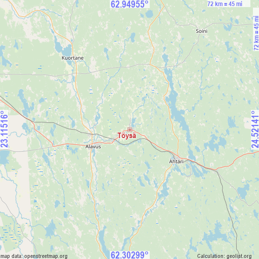
Töysä GPS coordinates[2]
62° 37' 40.908" North, 23° 49' 5.808" East
| Map corner | latitude | longitude |
|---|---|---|
| Upper-left | 62.94955°, | 23.11516° |
| Center: | 62.62803°, | 23.81828° |
| Lower-right: | 62.30299°, | 24.52141° |
| Map W x H: | 71.9×71.9 km | = 44.7×44.7mi |
| max Lat: | 69.90864° ⇑35.9% North |
| Töysä: | 62.62803° |
| min Lat: | ⇓64.1% South 59.83333° |
| min Long | Töysä | max Long |
| 21.2° | 23.81828° | 30.93276° |
| W 37%⇐ | ⇒63% E |
Elevation
Elevation of Töysä is 140 m = 459 ft, and this is 62.9 m = 206 ft above average elevation for this country.
| Max E: |
299 m = 981 ft | 10.3% |
| Töysä | 140 m 459 ft | |
| Avg. | 77.1 m = 253 ft | |
Min E: |
1 m = 3 ft | 89.7% |
See also: Finland elevation on elevation.city.
Geographical zone
Töysä is located in North temperate zone (between Tropic of Cancer and the Arctic Circle). Distance of this North polar circle is 437.6 km =271.9 mi to North.| Distance of | km | miles | from Töysä |
|---|---|---|---|
| North Pole | 3043.5 | 1891.1 | to North |
| Arctic Circle | 437.6 | 271.9 | to North |
| Tropic Cancer | 4357.7 | 2707.7 | to South |
| Equator | 6963.6 | 4327 | to South |


Nearby cities:
15 places around Töysä: (largest is in red/bold)
• Alajärvi
41.4 km =25.7 mi,  359°
359°
• Alavus
11.4 km =7.1 mi,  244°
244°
• Jalasjärvi
56.5 km =35.1 mi,  255°
255°
• Karstula
55.8 km =34.7 mi,  61°
61°
• Kuortane
25.1 km =15.6 mi,  319°
319°
• Lapua
56 km =34.8 mi,  312°
312°
• Lehtimäki
18 km =11.2 mi,  16°
16°
• Multia
54.8 km =34.1 mi,  115°
115°
• Nurmo
51.4 km =31.9 mi,  295°
295°
• Pylkönmäki
50.3 km =31.3 mi,  85°
85°
• Seinäjoki
53.8 km =33.4 mi,  290°
290°
• Soini
33.4 km =20.8 mi,  37°
37°
• Virrat
42.3 km =26.3 mi,  182°
182°
• Ähtäri
14.9 km =9.3 mi, 123°
• Älajärvi
41.4 km =25.7 mi, 359°
Sources, notices
• [Note1] Compared only with cities in Finland existing in our database
• [Src1] Map data: © OpenStreetMap contributors (CC-BY-SA)
• [Src2] Other city data from geonames.org with taken over terms of usage.
• [Src3] Geographical zone / Annual Mean Temperature by Robert A. Rohde @ Wikipedia
