Karstula geodata
Karstula (Central Finland) is a seat of a third-order administrative division; located in Finland in Europe/Helsinki (GMT+3) time zone. With population of 4,718 people, there are 221 cities with bigger population in this country. Compared to other cities in Finland, 68.2% of cities are located further ↓South; 50.4% of cities are located further ←West and 93.4% of cities have lower elevation than Karstula. Note1
Administrative division(s):
- Level 1: Central Finland
- Level 2: Saarijärvi-Viitasaari
- Level 3: Karstula


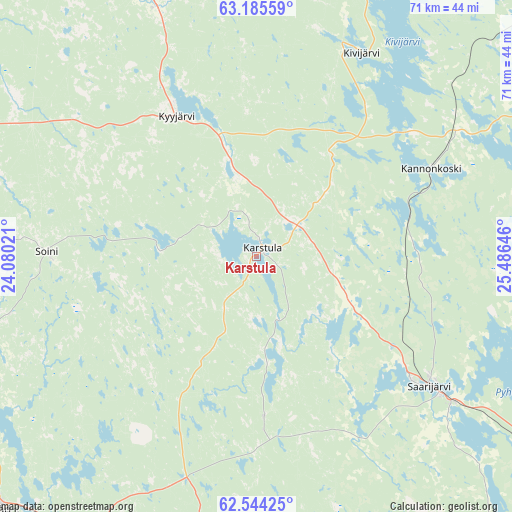
Karstula GPS coordinates[2]
62° 52' 0.012" North, 24° 46' 59.988" East
| Map corner | latitude | longitude |
|---|---|---|
| Upper-left | 63.18559°, | 24.08021° |
| Center: | 62.86667°, | 24.78333° |
| Lower-right: | 62.54425°, | 25.48646° |
| Map W x H: | 71.3×71.3 km | = 44.3×44.3mi |
| max Lat: | 69.90864° ⇑31.8% North |
| Karstula: | 62.86667° |
| min Lat: | ⇓68.2% South 59.83333° |
| min Long | Karstula | max Long |
| 21.2° | 24.78333° | 30.93276° |
| W 50.4%⇐ | ⇒49.6% E |
Elevation
Elevation of Karstula is 151 m = 495 ft, and this is 73.9 m = 242 ft above average elevation for this country.
| Max E: |
299 m = 981 ft | 6.6% |
| Karstula | 151 m 495 ft | |
| Avg. | 77.1 m = 253 ft | |
Min E: |
1 m = 3 ft | 93.4% |
See also: Finland elevation on elevation.city.
Geographical zone
Karstula is located in North temperate zone (between Tropic of Cancer and the Arctic Circle). Distance of this North polar circle is 411.1 km =255.4 mi to North.| Distance of | km | miles | from Karstula |
|---|---|---|---|
| North Pole | 3016.9 | 1874.6 | to North |
| Arctic Circle | 411.1 | 255.4 | to North |
| Tropic Cancer | 4384.2 | 2724.2 | to South |
| Equator | 6990.1 | 4343.4 | to South |


Nearby cities:
15 places around Karstula: (largest is in red/bold)
• Alajärvi
51.1 km =31.8 mi,  286°
286°
• Kannonkoski
26.1 km =16.2 mi,  64°
64°
• Kinnula
56.4 km =35 mi,  9°
9°
• Kivijärvi
31.8 km =19.8 mi,  27°
27°
• Kyyjärvi
21.5 km =13.4 mi,  329°
329°
• Lehtimäki
45 km =28 mi,  258°
258°
• Multia
50 km =31.1 mi,  180°
180°
• Perho
43.1 km =26.8 mi, 334°
• Pylkönmäki
22.3 km =13.9 mi, 177°
• Saarijärvi
29.9 km =18.6 mi,  126°
126°
• Soini
28.7 km =17.8 mi,  270°
270°
• Töysä
55.8 km =34.7 mi,  241°
241°
• Uurainen
53.1 km =33 mi,  140°
140°
• Ähtäri
50.6 km =31.4 mi,  226°
226°
• Älajärvi
51.2 km =31.8 mi, 286°
Sources, notices
• [Note1] Compared only with cities in Finland existing in our database
• [Src1] Map data: © OpenStreetMap contributors (CC-BY-SA)
• [Src2] Other city data from geonames.org with taken over terms of usage.
• [Src3] Geographical zone / Annual Mean Temperature by Robert A. Rohde @ Wikipedia
