Ähtäri geodata
Ähtäri (Southern Ostrobothnia) is a seat of a third-order administrative division; located in Finland in Europe/Helsinki (GMT+3) time zone. With population of 6,835 people, there are 161 cities with bigger population in this country. Compared to other cities in Finland, 62.4% of cities are located further ↓South; 60% of cities are located further →East and 96.4% of cities have lower elevation than Ähtäri. Note1


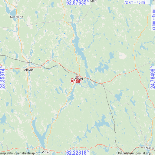
Ähtäri GPS coordinates[2]
62° 33' 14.508" North, 24° 3' 42.696" East
| Map corner | latitude | longitude |
|---|---|---|
| Upper-left | 62.87635°, | 23.35874° |
| Center: | 62.55403°, | 24.06186° |
| Lower-right: | 62.22818°, | 24.76499° |
| Map W x H: | 72.1×72.1 km | = 44.8×44.8mi |
| max Lat: | 69.90864° ⇑37.6% North |
| Ähtäri: | 62.55403° |
| min Lat: | ⇓62.4% South 59.83333° |
| min Long | Ähtäri | max Long |
| 21.2° | 24.06186° | 30.93276° |
| W 40%⇐ | ⇒60% E |
Elevation
Elevation of Ähtäri is 175 m = 574 ft, and this is 97.9 m = 321 ft above average elevation for this country.
| Max E: |
299 m = 981 ft | 3.6% |
| Ähtäri | 175 m 574 ft | |
| Avg. | 77.1 m = 253 ft | |
Min E: |
1 m = 3 ft | 96.4% |
See also: Finland elevation on elevation.city.
Geographical zone
Ähtäri is located in North temperate zone (between Tropic of Cancer and the Arctic Circle). Distance of this North polar circle is 445.8 km =277 mi to North.| Distance of | km | miles | from Ähtäri |
|---|---|---|---|
| North Pole | 3051.7 | 1896.2 | to North |
| Arctic Circle | 445.8 | 277 | to North |
| Tropic Cancer | 4349.4 | 2702.6 | to South |
| Equator | 6955.4 | 4321.9 | to South |


Nearby cities:
15 places around Ähtäri: (largest is in red/bold)
• Alajärvi
51.1 km =31.8 mi,  345°
345°
• Alavus
23 km =14.3 mi,  278°
278°
• Karstula
50.6 km =31.4 mi,  46°
46°
• Keuruu
45.8 km =28.5 mi,  134°
134°
• Kihniö
60 km =37.3 mi,  229°
229°
• Kuortane
39.6 km =24.6 mi,  313°
313°
• Kyyjärvi
59.1 km =36.7 mi,  25°
25°
• Lehtimäki
26.6 km =16.5 mi,  343°
343°
• Multia
40.1 km =24.9 mi,  112°
112°
• Pylkönmäki
39.8 km =24.7 mi,  71°
71°
• Saarijärvi
63.2 km =39.3 mi, 74°
• Soini
35.6 km =22.1 mi,  12°
12°
• Töysä
14.9 km =9.3 mi,  303°
303°
• Virrat
37 km =23 mi,  203°
203°
• Älajärvi
51.2 km =31.8 mi, 345°
Sources, notices
• [Note1] Compared only with cities in Finland existing in our database
• [Src1] Map data: © OpenStreetMap contributors (CC-BY-SA)
• [Src2] Other city data from geonames.org with taken over terms of usage.
• [Src3] Geographical zone / Annual Mean Temperature by Robert A. Rohde @ Wikipedia
