Säynätsalo geodata
Säynätsalo (Central Finland) is a populated place; located in Finland in Europe/Helsinki (GMT+3) time zone. With population of 3,322 people, there are 279 cities with bigger population in this country. Compared to other cities in Finland, 55.6% of cities are located further ↓South; 67.7% of cities are located further ←West and 53.2% of cities have higher elevation than Säynätsalo. Note1


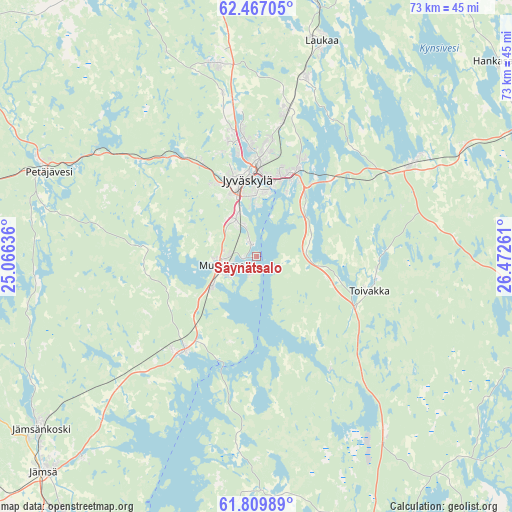
Säynätsalo GPS coordinates[2]
62° 8' 24.9" North, 25° 46' 10.128" East
| Map corner | latitude | longitude |
|---|---|---|
| Upper-left | 62.46705°, | 25.06636° |
| Center: | 62.14025°, | 25.76948° |
| Lower-right: | 61.80989°, | 26.47261° |
| Map W x H: | 73.1×73.1 km | = 45.4×45.4mi |
| max Lat: | 69.90864° ⇑44.4% North |
| Säynätsalo: | 62.14025° |
| min Lat: | ⇓55.6% South 59.83333° |
| min Long | Säynätsalo | max Long |
| 21.2° | 25.76948° | 30.93276° |
| W 67.7%⇐ | ⇒32.3% E |
Elevation
Elevation of Säynätsalo is 75 m = 246 ft, and this is 2.1 m = 7 ft below average elevation for this country.
| Max E: |
299 m = 981 ft | 53.2% |
| Avg. | 77.1 m = 253 ft | |
| Säynätsalo | 75 m = 246 ft | |
Min E: |
1 m = 3 ft | 46.8% |
See also: Finland elevation on elevation.city.
Geographical zone
Säynätsalo is located in North temperate zone (between Tropic of Cancer and the Arctic Circle). Distance of this North polar circle is 491.8 km =305.6 mi to North.| Distance of | km | miles | from Säynätsalo |
|---|---|---|---|
| North Pole | 3097.7 | 1924.8 | to North |
| Arctic Circle | 491.8 | 305.6 | to North |
| Tropic Cancer | 4303.4 | 2674 | to South |
| Equator | 6909.3 | 4293.2 | to South |


Nearby cities:
15 places around Säynätsalo: (largest is in red/bold)
• Hankasalmi
43.7 km =27.2 mi,  51°
51°
• Joutsa
48.8 km =30.3 mi,  158°
158°
• Jyväskylä
11.5 km =7.1 mi,  347°
347°
• Jämsä
43.1 km =26.8 mi,  224°
224°
• Jämsänkoski
39.8 km =24.7 mi,  231°
231°
• Kangasniemi
48.6 km =30.2 mi,  109°
109°
• Korpilahti
17.9 km =11.1 mi, 219°
• Laukaa
31.9 km =19.8 mi,  17°
17°
• Leivonmäki
31.5 km =19.6 mi,  143°
143°
• Luhanka
38.3 km =23.8 mi,  185°
185°
• Muurame
5.4 km =3.4 mi,  261°
261°
• Petäjävesi
32 km =19.9 mi,  292°
292°
• Suolahti
47.3 km =29.4 mi,  5°
5°
• Toivakka
16.9 km =10.5 mi, 105°
• Uurainen
43.3 km =26.9 mi,  337°
337°
Sources, notices
• [Note1] Compared only with cities in Finland existing in our database
• [Src1] Map data: © OpenStreetMap contributors (CC-BY-SA)
• [Src2] Other city data from geonames.org with taken over terms of usage.
• [Src3] Geographical zone / Annual Mean Temperature by Robert A. Rohde @ Wikipedia
