Reisjärvi geodata
Reisjärvi (Northern Ostrobothnia) is a seat of a third-order administrative division; located in Finland in Europe/Helsinki (GMT+3) time zone. With population of 3,052 people, there are 293 cities with bigger population in this country. Compared to other cities in Finland, 80.8% of cities are located further ↓South; 53.4% of cities are located further ←West and 81.4% of cities have lower elevation than Reisjärvi. Note1
Administrative division(s):
- Level 1: Northern Ostrobothnia
- Level 2: Nivala-Haapajärvi
- Level 3: Reisjärvi


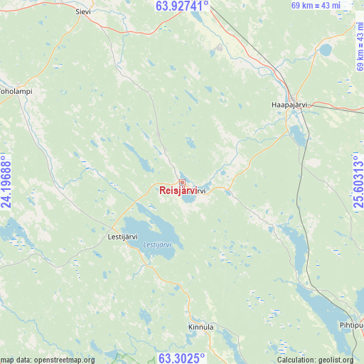
Reisjärvi GPS coordinates[2]
63° 37' 0.012" North, 24° 54' 0" East
| Map corner | latitude | longitude |
|---|---|---|
| Upper-left | 63.92741°, | 24.19688° |
| Center: | 63.61667°, | 24.9° |
| Lower-right: | 63.3025°, | 25.60313° |
| Map W x H: | 69.5×69.5 km | = 43.2×43.2mi |
| max Lat: | 69.90864° ⇑19.2% North |
| Reisjärvi: | 63.61667° |
| min Lat: | ⇓80.8% South 59.83333° |
| min Long | Reisjärvi | max Long |
| 21.2° | 24.9° | 30.93276° |
| W 53.4%⇐ | ⇒46.6% E |
Elevation
Elevation of Reisjärvi is 119 m = 390 ft, and this is 41.9 m = 137 ft above average elevation for this country.
| Max E: |
299 m = 981 ft | 18.6% |
| Reisjärvi | 119 m 390 ft | |
| Avg. | 77.1 m = 253 ft | |
Min E: |
1 m = 3 ft | 81.4% |
See also: Finland elevation on elevation.city.
Geographical zone
Reisjärvi is located in North temperate zone (between Tropic of Cancer and the Arctic Circle). Distance of this North polar circle is 327.7 km =203.6 mi to North.| Distance of | km | miles | from Reisjärvi |
|---|---|---|---|
| North Pole | 2933.6 | 1822.9 | to North |
| Arctic Circle | 327.7 | 203.6 | to North |
| Tropic Cancer | 4467.6 | 2776 | to South |
| Equator | 7073.5 | 4395.3 | to South |


Nearby cities:
15 places around Reisjärvi: (largest is in red/bold)
• Haapajärvi
26 km =16.2 mi,  55°
55°
• Halsua
40 km =24.9 mi,  245°
245°
• Kinnula
26.1 km =16.2 mi,  174°
174°
• Kinnula
28 km =17.4 mi, 173°
• Kivijärvi
56 km =34.8 mi, 170°
• Lestijärvi
15.5 km =9.6 mi,  233°
233°
• Nivala
33.5 km =20.8 mi,  5°
5°
• Perho
50.6 km =31.4 mi,  208°
208°
• Pihtipudas
42 km =26.1 mi,  128°
128°
• Pyhäjärvi
49.7 km =30.9 mi,  83°
83°
• Pyhäsalmi
54 km =33.6 mi, 82°
• Sievi
37.1 km =23.1 mi,  328°
328°
• Toholampi
36.1 km =22.4 mi,  297°
297°
• Ullava
40.4 km =25.1 mi,  267°
267°
• Ylivieska
54.6 km =33.9 mi,  341°
341°
Sources, notices
• [Note1] Compared only with cities in Finland existing in our database
• [Src1] Map data: © OpenStreetMap contributors (CC-BY-SA)
• [Src2] Other city data from geonames.org with taken over terms of usage.
• [Src3] Geographical zone / Annual Mean Temperature by Robert A. Rohde @ Wikipedia
