Lestijärvi geodata
Lestijärvi (Central Ostrobothnia) is a seat of a third-order administrative division; located in Finland in Europe/Helsinki (GMT+3) time zone. With population of 924 people, there are 429 cities with bigger population in this country. Compared to other cities in Finland, 79.5% of cities are located further ↓South; 51.7% of cities are located further →East and 94.2% of cities have lower elevation than Lestijärvi. Note1


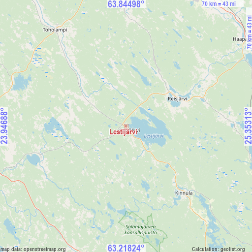
Lestijärvi GPS coordinates[2]
63° 31' 59.988" North, 24° 39' 0" East
| Map corner | latitude | longitude |
|---|---|---|
| Upper-left | 63.84498°, | 23.94688° |
| Center: | 63.53333°, | 24.65° |
| Lower-right: | 63.21824°, | 25.35313° |
| Map W x H: | 69.7×69.7 km | = 43.3×43.3mi |
| max Lat: | 69.90864° ⇑20.5% North |
| Lestijärvi: | 63.53333° |
| min Lat: | ⇓79.5% South 59.83333° |
| min Long | Lestijärvi | max Long |
| 21.2° | 24.65° | 30.93276° |
| W 48.3%⇐ | ⇒51.7% E |
Elevation
Elevation of Lestijärvi is 155 m = 509 ft, and this is 77.9 m = 256 ft above average elevation for this country.
| Max E: |
299 m = 981 ft | 5.8% |
| Lestijärvi | 155 m 509 ft | |
| Avg. | 77.1 m = 253 ft | |
Min E: |
1 m = 3 ft | 94.2% |
See also: Finland elevation on elevation.city.
Geographical zone
Lestijärvi is located in North temperate zone (between Tropic of Cancer and the Arctic Circle). Distance of this North polar circle is 336.9 km =209.3 mi to North.| Distance of | km | miles | from Lestijärvi |
|---|---|---|---|
| North Pole | 2942.8 | 1828.6 | to North |
| Arctic Circle | 336.9 | 209.3 | to North |
| Tropic Cancer | 4458.3 | 2770.3 | to South |
| Equator | 7064.2 | 4389.5 | to South |


Nearby cities:
15 places around Lestijärvi: (largest is in red/bold)
• Haapajärvi
41.5 km =25.8 mi,  54°
54°
• Halsua
25.1 km =15.6 mi,  252°
252°
• Kannus
55 km =34.2 mi,  317°
317°
• Kaustinen
47.7 km =29.6 mi,  272°
272°
• Kinnula
22.4 km =13.9 mi,  138°
138°
• Kinnula
24.3 km =15.1 mi, 139°
• Kivijärvi
50.7 km =31.5 mi,  155°
155°
• Nivala
45.4 km =28.2 mi,  20°
20°
• Perho
37.1 km =23.1 mi,  198°
198°
• Pihtipudas
48.5 km =30.1 mi,  110°
110°
• Reisjärvi
15.5 km =9.6 mi, 53°
• Sievi
41.4 km =25.7 mi,  349°
349°
• Toholampi
32.6 km =20.3 mi, 322°
• Ullava
29 km =18 mi,  284°
284°
• Veteli
43.4 km =27 mi,  261°
261°
Sources, notices
• [Note1] Compared only with cities in Finland existing in our database
• [Src1] Map data: © OpenStreetMap contributors (CC-BY-SA)
• [Src2] Other city data from geonames.org with taken over terms of usage.
• [Src3] Geographical zone / Annual Mean Temperature by Robert A. Rohde @ Wikipedia
