Toholampi geodata
Toholampi (Central Ostrobothnia) is a seat of a third-order administrative division; located in Finland in Europe/Helsinki (GMT+3) time zone. With population of 3,481 people, there are 271 cities with bigger population in this country. Compared to other cities in Finland, 83.3% of cities are located further ↓South; 57.7% of cities are located further →East and 59.4% of cities have lower elevation than Toholampi. Note1


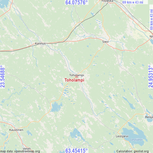
Toholampi GPS coordinates[2]
63° 46' 0.012" North, 24° 15' 0" East
| Map corner | latitude | longitude |
|---|---|---|
| Upper-left | 64.07576°, | 23.54688° |
| Center: | 63.76667°, | 24.25° |
| Lower-right: | 63.45415°, | 24.95313° |
| Map W x H: | 69.1×69.1 km | = 42.9×42.9mi |
| max Lat: | 69.90864° ⇑16.7% North |
| Toholampi: | 63.76667° |
| min Lat: | ⇓83.3% South 59.83333° |
| min Long | Toholampi | max Long |
| 21.2° | 24.25° | 30.93276° |
| W 42.3%⇐ | ⇒57.7% E |
Elevation
Elevation of Toholampi is 94 m = 308 ft, and this is 16.9 m = 55 ft above average elevation for this country.
| Max E: |
299 m = 981 ft | 40.6% |
| Toholampi | 94 m 308 ft | |
| Avg. | 77.1 m = 253 ft | |
Min E: |
1 m = 3 ft | 59.4% |
See also: Finland elevation on elevation.city.
Geographical zone
Toholampi is located in North temperate zone (between Tropic of Cancer and the Arctic Circle). Distance of this North polar circle is 311 km =193.2 mi to North.| Distance of | km | miles | from Toholampi |
|---|---|---|---|
| North Pole | 2916.9 | 1812.5 | to North |
| Arctic Circle | 311 | 193.2 | to North |
| Tropic Cancer | 4484.3 | 2786.4 | to South |
| Equator | 7090.2 | 4405.6 | to South |


Nearby cities:
15 places around Toholampi: (largest is in red/bold)
• Alavieska
44.5 km =27.7 mi,  3°
3°
• Haapajärvi
53.3 km =33.1 mi,  91°
91°
• Halsua
33.6 km =20.9 mi,  187°
187°
• Himanka
43.9 km =27.3 mi,  318°
318°
• Kannus
22.7 km =14.1 mi,  310°
310°
• Kaustinen
36.8 km =22.9 mi,  228°
228°
• Kälviä
40.5 km =25.2 mi,  284°
284°
• Lestijärvi
32.6 km =20.3 mi,  142°
142°
• Lohtaja
46.4 km =28.8 mi, 308°
• Nivala
38.9 km =24.2 mi,  64°
64°
• Reisjärvi
36.1 km =22.4 mi,  117°
117°
• Sievi
19.2 km =11.9 mi,  39°
39°
• Ullava
20.3 km =12.6 mi,  203°
203°
• Veteli
39.5 km =24.5 mi,  215°
215°
• Ylivieska
38.1 km =23.7 mi,  22°
22°
Sources, notices
• [Note1] Compared only with cities in Finland existing in our database
• [Src1] Map data: © OpenStreetMap contributors (CC-BY-SA)
• [Src2] Other city data from geonames.org with taken over terms of usage.
• [Src3] Geographical zone / Annual Mean Temperature by Robert A. Rohde @ Wikipedia
