Pori geodata
Pori (Satakunta) is a seat of a first-order administrative division; located in Finland in Europe/Helsinki (GMT+3) time zone. With population of 76,772 people, there are 9 cities with bigger population in this country. Compared to other cities in Finland, 56.8% of cities are located further ↑North; 93.6% of cities are located further →East and 79.9% of cities have higher elevation than Pori. Note1


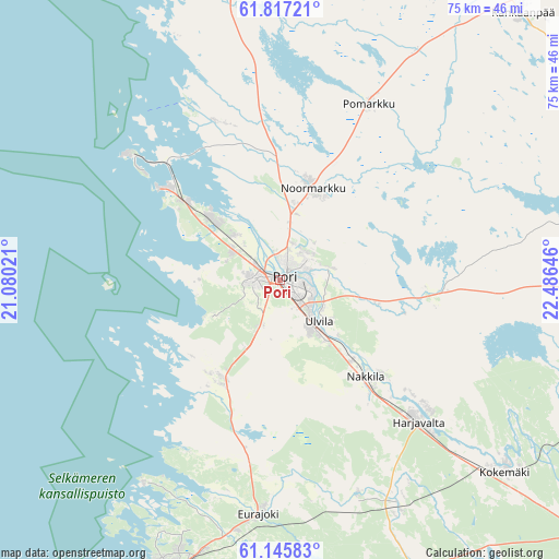
Pori GPS coordinates[2]
61° 28' 59.988" North, 21° 46' 59.988" East
| Map corner | latitude | longitude |
|---|---|---|
| Upper-left | 61.81721°, | 21.08021° |
| Center: | 61.48333°, | 21.78333° |
| Lower-right: | 61.14583°, | 22.48646° |
| Map W x H: | 74.7×74.6 km | = 46.4×46.4mi |
| max Lat: | 69.90864° ⇑56.8% North |
| Pori: | 61.48333° |
| min Lat: | ⇓43.2% South 59.83333° |
| min Long | Pori | max Long |
| 21.2° | 21.78333° | 30.93276° |
| W 6.4%⇐ | ⇒93.6% E |
Elevation
Elevation of Pori is 19 m = 62 ft, and this is 58.1 m = 191 ft below average elevation for this country.
| Max E: |
299 m = 981 ft | 79.9% |
| Avg. | 77.1 m = 253 ft | |
| Pori | 19 m = 62 ft | |
Min E: |
1 m = 3 ft | 20.1% |
See also: Pori elevation on elevation.city.
Geographical zone
Pori is located in North temperate zone (between Tropic of Cancer and the Arctic Circle). Distance of this North polar circle is 564.9 km =351 mi to North.| Distance of | km | miles | from Pori |
|---|---|---|---|
| North Pole | 3170.8 | 1970.2 | to North |
| Arctic Circle | 564.9 | 351 | to North |
| Tropic Cancer | 4230.4 | 2628.6 | to South |
| Equator | 6836.3 | 4247.9 | to South |


Nearby cities:
15 places around Pori: (largest is in red/bold)
• Eura
43.2 km =26.8 mi,  154°
154°
• Eurajoki
31.6 km =19.6 mi,  184°
184°
• Harjavalta
26.3 km =16.3 mi,  134°
134°
• Kiikoinen
42.3 km =26.3 mi,  94°
94°
• Kiukainen
33.7 km =20.9 mi, 151°
• Kokemäki
39.6 km =24.6 mi, 129°
• Kullaa
20.1 km =12.5 mi, 94°
• Lappi
42.7 km =26.5 mi, 176°
• Luvia
15.7 km =9.8 mi,  212°
212°
• Längelmäki
25 km =15.5 mi,  42°
42°
• Nakkila
17.4 km =10.8 mi,  138°
138°
• Noormarkku
13 km =8.1 mi,  20°
20°
• Pomarkku
26.2 km =16.3 mi,  27°
27°
• Rauma
42.2 km =26.2 mi,  200°
200°
• Ulvila
7.7 km =4.8 mi, 142°
Sources, notices
• [Note1] Compared only with cities in Finland existing in our database
• [Src1] Map data: © OpenStreetMap contributors (CC-BY-SA)
• [Src2] Other city data from geonames.org with taken over terms of usage.
• [Src3] Geographical zone / Annual Mean Temperature by Robert A. Rohde @ Wikipedia
