Noormarkku geodata
Noormarkku (Satakunta) is a populated place; located in Finland in Europe/Helsinki (GMT+3) time zone. With population of 6,076 people, there are 175 cities with bigger population in this country. Compared to other cities in Finland, 54.1% of cities are located further ↑North; 92.5% of cities are located further →East and 68.2% of cities have higher elevation than Noormarkku. Note1


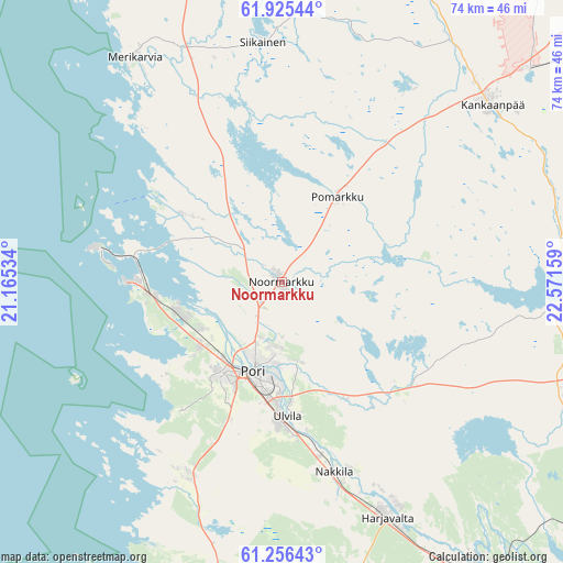
Noormarkku GPS coordinates[2]
61° 35' 33.864" North, 21° 52' 6.456" East
| Map corner | latitude | longitude |
|---|---|---|
| Upper-left | 61.92544°, | 21.16534° |
| Center: | 61.59274°, | 21.86846° |
| Lower-right: | 61.25643°, | 22.57159° |
| Map W x H: | 74.4×74.4 km | = 46.2×46.2mi |
| max Lat: | 69.90864° ⇑54.1% North |
| Noormarkku: | 61.59274° |
| min Lat: | ⇓45.9% South 59.83333° |
| min Long | Noormarkku | max Long |
| 21.2° | 21.86846° | 30.93276° |
| W 7.5%⇐ | ⇒92.5% E |
Elevation
Elevation of Noormarkku is 44 m = 144 ft, and this is 33.1 m = 109 ft below average elevation for this country.
| Max E: |
299 m = 981 ft | 68.2% |
| Avg. | 77.1 m = 253 ft | |
| Noormarkku | 44 m = 144 ft | |
Min E: |
1 m = 3 ft | 31.8% |
See also: Finland elevation on elevation.city.
Geographical zone
Noormarkku is located in North temperate zone (between Tropic of Cancer and the Arctic Circle). Distance of this North polar circle is 552.7 km =343.4 mi to North.| Distance of | km | miles | from Noormarkku |
|---|---|---|---|
| North Pole | 3158.6 | 1962.7 | to North |
| Arctic Circle | 552.7 | 343.4 | to North |
| Tropic Cancer | 4242.6 | 2636.2 | to South |
| Equator | 6848.5 | 4255.5 | to South |


Nearby cities:
15 places around Noormarkku: (largest is in red/bold)
• Eurajoki
44.3 km =27.5 mi,  189°
189°
• Harjavalta
33.8 km =21 mi,  155°
155°
• Kankaanpää
37 km =23 mi,  51°
51°
• Kiikoinen
40.6 km =25.2 mi,  112°
112°
• Kiukainen
43.4 km =27 mi, 164°
• Kullaa
20.7 km =12.9 mi,  131°
131°
• Lavia
38.7 km =24 mi,  88°
88°
• Luvia
28.5 km =17.7 mi,  206°
206°
• Längelmäki
13.8 km =8.6 mi,  62°
62°
• Merikarvia
35.3 km =21.9 mi,  326°
326°
• Nakkila
26.1 km =16.2 mi, 164°
• Pomarkku
13.4 km =8.3 mi,  33°
33°
• Pori
13 km =8.1 mi,  200°
200°
• Siikainen
31.7 km =19.7 mi,  355°
355°
• Ulvila
18.3 km =11.4 mi,  179°
179°
Sources, notices
• [Note1] Compared only with cities in Finland existing in our database
• [Src1] Map data: © OpenStreetMap contributors (CC-BY-SA)
• [Src2] Other city data from geonames.org with taken over terms of usage.
• [Src3] Geographical zone / Annual Mean Temperature by Robert A. Rohde @ Wikipedia
