Kalajoki geodata
Kalajoki (Northern Ostrobothnia) is a seat of a third-order administrative division; located in Finland in Europe/Helsinki (GMT+3) time zone. With population of 8,869 people, there are 120 cities with bigger population in this country. Compared to other cities in Finland, 87.4% of cities are located further ↓South; 61.3% of cities are located further →East and 84% of cities have higher elevation than Kalajoki. Note1


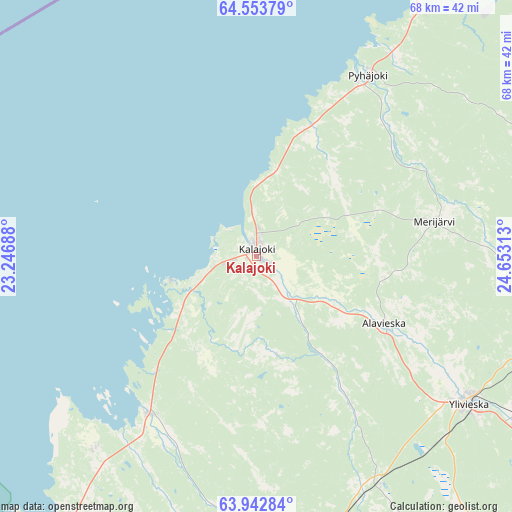
Kalajoki GPS coordinates[2]
64° 15' 0" North, 23° 57' 0" East
| Map corner | latitude | longitude |
|---|---|---|
| Upper-left | 64.55379°, | 23.24688° |
| Center: | 64.25°, | 23.95° |
| Lower-right: | 63.94284°, | 24.65313° |
| Map W x H: | 67.9×67.9 km | = 42.2×42.2mi |
| max Lat: | 69.90864° ⇑12.6% North |
| Kalajoki: | 64.25° |
| min Lat: | ⇓87.4% South 59.83333° |
| min Long | Kalajoki | max Long |
| 21.2° | 23.95° | 30.93276° |
| W 38.7%⇐ | ⇒61.3% E |
Elevation
Elevation of Kalajoki is 16 m = 52 ft, and this is 61.1 m = 200 ft below average elevation for this country.
| Max E: |
299 m = 981 ft | 84% |
| Avg. | 77.1 m = 253 ft | |
| Kalajoki | 16 m = 52 ft | |
Min E: |
1 m = 3 ft | 16% |
See also: Finland elevation on elevation.city.
Geographical zone
Kalajoki is located in North temperate zone (between Tropic of Cancer and the Arctic Circle). Distance of this North polar circle is 257.2 km =159.8 mi to North.| Distance of | km | miles | from Kalajoki |
|---|---|---|---|
| North Pole | 2863.1 | 1779 | to North |
| Arctic Circle | 257.2 | 159.8 | to North |
| Tropic Cancer | 4538 | 2819.8 | to South |
| Equator | 7143.9 | 4439 | to South |


Nearby cities:
15 places around Kalajoki: (largest is in red/bold)
• Alavieska
19.3 km =12 mi,  118°
118°
• Himanka
25.3 km =15.7 mi,  214°
214°
• Kannus
39 km =24.2 mi,  183°
183°
• Kokkola
60.7 km =37.7 mi,  221°
221°
• Kälviä
49.6 km =30.8 mi, 209°
• Lohtaja
33.1 km =20.6 mi, 220°
• Merijärvi
24.8 km =15.4 mi,  77°
77°
• Nivala
61.8 km =38.4 mi,  126°
126°
• Oulainen
41.1 km =25.5 mi,  87°
87°
• Pyhäjoki
27.7 km =17.2 mi,  29°
29°
• Raahe
54.5 km =33.9 mi, 27°
• Sievi
47.2 km =29.3 mi,  145°
145°
• Toholampi
55.7 km =34.6 mi,  164°
164°
• Vihanti
56.5 km =35.1 mi,  62°
62°
• Ylivieska
34.5 km =21.4 mi, 122°
Sources, notices
• [Note1] Compared only with cities in Finland existing in our database
• [Src1] Map data: © OpenStreetMap contributors (CC-BY-SA)
• [Src2] Other city data from geonames.org with taken over terms of usage.
• [Src3] Geographical zone / Annual Mean Temperature by Robert A. Rohde @ Wikipedia
