Nuijamaa geodata
Nuijamaa (South Karelia) is a populated place; located in Finland in Europe/Helsinki (GMT+3) time zone. With population of 1,199 people, there are 416 cities with bigger population in this country. Compared to other cities in Finland, 69.9% of cities are located further ↑North; 92.5% of cities are located further ←West and 69.9% of cities have higher elevation than Nuijamaa. Note1


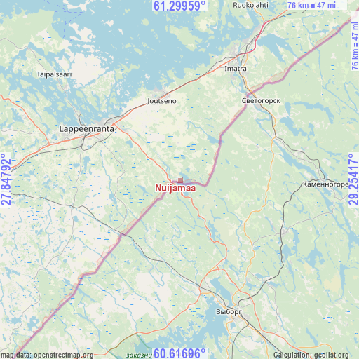
Nuijamaa GPS coordinates[2]
60° 57' 36.396" North, 28° 33' 3.744" East
| Map corner | latitude | longitude |
|---|---|---|
| Upper-left | 61.29959°, | 27.84792° |
| Center: | 60.96011°, | 28.55104° |
| Lower-right: | 60.61696°, | 29.25417° |
| Map W x H: | 75.9×75.9 km | = 47.2×47.2mi |
| max Lat: | 69.90864° ⇑69.9% North |
| Nuijamaa: | 60.96011° |
| min Lat: | ⇓30.1% South 59.83333° |
| min Long | Nuijamaa | max Long |
| 21.2° | 28.55104° | 30.93276° |
| W 92.5%⇐ | ⇒7.5% E |
Elevation
Elevation of Nuijamaa is 40 m = 131 ft, and this is 37.1 m = 122 ft below average elevation for this country.
| Max E: |
299 m = 981 ft | 69.9% |
| Avg. | 77.1 m = 253 ft | |
| Nuijamaa | 40 m = 131 ft | |
Min E: |
1 m = 3 ft | 30.1% |
See also: Finland elevation on elevation.city.
Geographical zone
Nuijamaa is located in North temperate zone (between Tropic of Cancer and the Arctic Circle). Distance of this North polar circle is 623 km =387.1 mi to North.| Distance of | km | miles | from Nuijamaa |
|---|---|---|---|
| North Pole | 3228.9 | 2006.3 | to North |
| Arctic Circle | 623 | 387.1 | to North |
| Tropic Cancer | 4172.2 | 2592.5 | to South |
| Equator | 6778.1 | 4211.7 | to South |


Nearby cities:
15 places around Nuijamaa: (largest is in red/bold)
• Imatra
25.9 km =16.1 mi,  24°
24°
• Joutseno
17.7 km =11 mi,  352°
352°
• Lappeenranta
22.4 km =13.9 mi,  299°
299°
• Lemi
41.7 km =25.9 mi,  285°
285°
• Luumäki
52.5 km =32.6 mi,  265°
265°
• Miehikkälä
56.5 km =35.1 mi,  234°
234°
• Puumala
66.2 km =41.1 mi,  342°
342°
• Rautjärvi
67.8 km =42.1 mi,  39°
39°
• Ruokolahti
39 km =24.2 mi, 22°
• Savitaipale
53 km =32.9 mi, 300°
• Taavetti
53.4 km =33.2 mi,  264°
264°
• Taipalsaari
34.2 km =21.3 mi,  308°
308°
• Virojoki
62.5 km =38.8 mi, 227°
• Virolahti
68.2 km =42.4 mi,  223°
223°
• Ylämaa
34.7 km =21.6 mi,  239°
239°
Sources, notices
• [Note1] Compared only with cities in Finland existing in our database
• [Src1] Map data: © OpenStreetMap contributors (CC-BY-SA)
• [Src2] Other city data from geonames.org with taken over terms of usage.
• [Src3] Geographical zone / Annual Mean Temperature by Robert A. Rohde @ Wikipedia
