Virolahti geodata
Virolahti (Kymenlaakso) is a seat of a third-order administrative division; located in Finland in Europe/Helsinki (GMT+3) time zone. In our database, there are 443 cities with bigger population. Compared to other cities in Finland, 84.8% of cities are located further ↑North; 85.5% of cities are located further ←West and 92.7% of cities have higher elevation than Virolahti. Note1


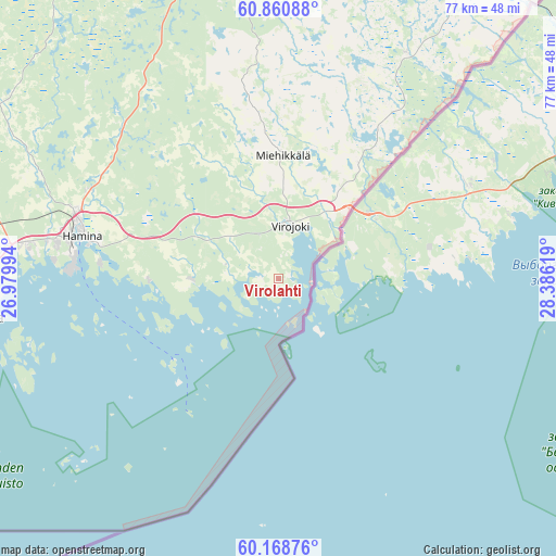
Virolahti GPS coordinates[2]
60° 31' 0.012" North, 27° 40' 59.016" East
| Map corner | latitude | longitude |
|---|---|---|
| Upper-left | 60.86088°, | 26.97994° |
| Center: | 60.51667°, | 27.68306° |
| Lower-right: | 60.16876°, | 28.38619° |
| Map W x H: | 77×77 km | = 47.8×47.8mi |
| max Lat: | 69.90864° ⇑84.8% North |
| Virolahti: | 60.51667° |
| min Lat: | ⇓15.2% South 59.83333° |
| min Long | Virolahti | max Long |
| 21.2° | 27.68306° | 30.93276° |
| W 85.5%⇐ | ⇒14.5% E |
Elevation
Elevation of Virolahti is 10 m = 33 ft, and this is 67.1 m = 220 ft below average elevation for this country.
| Max E: |
299 m = 981 ft | 92.7% |
| Avg. | 77.1 m = 253 ft | |
| Virolahti | 10 m = 33 ft | |
Min E: |
1 m = 3 ft | 7.3% |
See also: Finland elevation on elevation.city.
Geographical zone
Virolahti is located in North temperate zone (between Tropic of Cancer and the Arctic Circle). Distance of this North polar circle is 672.4 km =417.8 mi to North.| Distance of | km | miles | from Virolahti |
|---|---|---|---|
| North Pole | 3278.2 | 2037 | to North |
| Arctic Circle | 672.4 | 417.8 | to North |
| Tropic Cancer | 4122.9 | 2561.9 | to South |
| Equator | 6728.8 | 4181.1 | to South |


Nearby cities:
15 places around Virolahti: (largest is in red/bold)
• Anjala
49.9 km =31 mi,  291°
291°
• Broby
52.9 km =32.9 mi,  267°
267°
• Hamina
27.2 km =16.9 mi,  282°
282°
• Karhula
41.1 km =25.5 mi, 270°
• Katariina
41.2 km =25.6 mi,  260°
260°
• Kotka
40.8 km =25.4 mi, 262°
• Kouvola
66.2 km =41.1 mi,  306°
306°
• Lappeenranta
66.2 km =41.1 mi,  24°
24°
• Lemi
61 km =37.9 mi,  6°
6°
• Luumäki
45.9 km =28.5 mi,  353°
353°
• Miehikkälä
16.7 km =10.4 mi,  3°
3°
• Pyhtää
62.4 km =38.8 mi, 267°
• Taavetti
44.9 km =27.9 mi, 351°
• Virojoki
7.1 km =4.4 mi, 9°
• Ylämaa
35.9 km =22.3 mi,  28°
28°
Sources, notices
• [Note1] Compared only with cities in Finland existing in our database
• [Src1] Map data: © OpenStreetMap contributors (CC-BY-SA)
• [Src2] Other city data from geonames.org with taken over terms of usage.
• [Src3] Geographical zone / Annual Mean Temperature by Robert A. Rohde @ Wikipedia
