Mänttä geodata
Mänttä (Pirkanmaa) is a seat of a third-order administrative division; located in Finland in Europe/Helsinki (GMT+3) time zone. With population of 6,459 people, there are 167 cities with bigger population in this country. Compared to other cities in Finland, 53.6% of cities are located further ↓South; 52.1% of cities are located further →East and 68.2% of cities have lower elevation than Mänttä. Note1


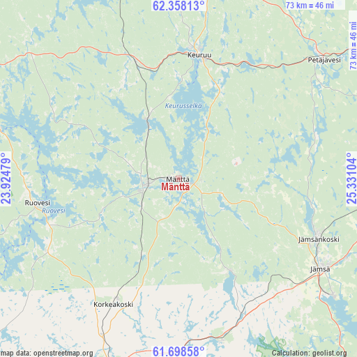
Mänttä GPS coordinates[2]
62° 1' 48.504" North, 24° 37' 40.476" East
| Map corner | latitude | longitude |
|---|---|---|
| Upper-left | 62.35813°, | 23.92479° |
| Center: | 62.03014°, | 24.62791° |
| Lower-right: | 61.69858°, | 25.33104° |
| Map W x H: | 73.3×73.3 km | = 45.5×45.5mi |
| max Lat: | 69.90864° ⇑46.4% North |
| Mänttä: | 62.03014° |
| min Lat: | ⇓53.6% South 59.83333° |
| min Long | Mänttä | max Long |
| 21.2° | 24.62791° | 30.93276° |
| W 47.9%⇐ | ⇒52.1% E |
Elevation
Elevation of Mänttä is 104 m = 341 ft, and this is 26.9 m = 88 ft above average elevation for this country.
| Max E: |
299 m = 981 ft | 31.8% |
| Mänttä | 104 m 341 ft | |
| Avg. | 77.1 m = 253 ft | |
Min E: |
1 m = 3 ft | 68.2% |
See also: Finland elevation on elevation.city.
Geographical zone
Mänttä is located in North temperate zone (between Tropic of Cancer and the Arctic Circle). Distance of this North polar circle is 504.1 km =313.2 mi to North.| Distance of | km | miles | from Mänttä |
|---|---|---|---|
| North Pole | 3110 | 1932.5 | to North |
| Arctic Circle | 504.1 | 313.2 | to North |
| Tropic Cancer | 4291.2 | 2666.4 | to South |
| Equator | 6897.1 | 4285.7 | to South |


Nearby cities:
15 places around Mänttä: (largest is in red/bold)
• Juupajoki
29 km =18 mi,  207°
207°
• Jämsä
34.7 km =21.6 mi,  122°
122°
• Jämsänkoski
30.9 km =19.2 mi,  113°
113°
• Keuruu
26.6 km =16.5 mi,  8°
8°
• Korpilahti
48.1 km =29.9 mi,  91°
91°
• Kuhmalahti
59 km =36.7 mi,  183°
183°
• Kuhmoinen
59.2 km =36.8 mi,  150°
150°
• Kuru
50.5 km =31.4 mi,  250°
250°
• Multia
43.7 km =27.2 mi, 10°
• Muurame
55.3 km =34.4 mi,  78°
78°
• Orivesi
41.7 km =25.9 mi,  199°
199°
• Petäjävesi
38.5 km =23.9 mi,  50°
50°
• Ruovesi
30.2 km =18.8 mi,  260°
260°
• Vilppula
6.5 km =4 mi, 261°
• Virrat
50.3 km =31.3 mi,  298°
298°
Sources, notices
• [Note1] Compared only with cities in Finland existing in our database
• [Src1] Map data: © OpenStreetMap contributors (CC-BY-SA)
• [Src2] Other city data from geonames.org with taken over terms of usage.
• [Src3] Geographical zone / Annual Mean Temperature by Robert A. Rohde @ Wikipedia
