Korpilahti geodata
Korpilahti (Central Finland) is a seat of a third-order administrative division; located in Finland in Europe/Helsinki (GMT+3) time zone. With population of 5,050 people, there are 206 cities with bigger population in this country. Compared to other cities in Finland, 52.8% of cities are located further ↓South; 64.3% of cities are located further ←West and 72.9% of cities have lower elevation than Korpilahti. Note1


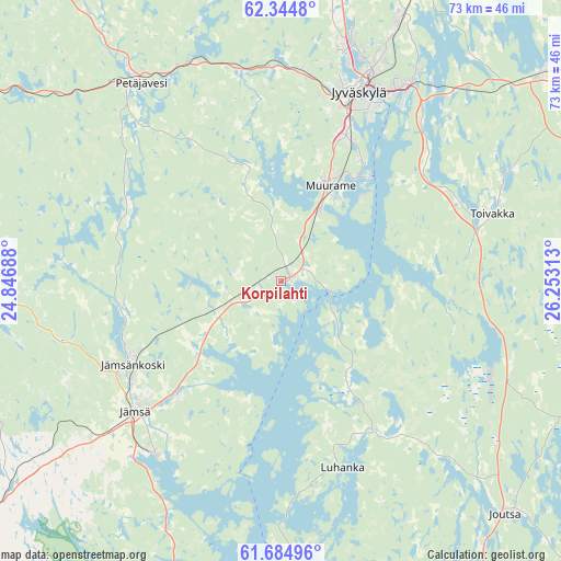
Korpilahti GPS coordinates[2]
62° 1' 0.012" North, 25° 33' 0" East
| Map corner | latitude | longitude |
|---|---|---|
| Upper-left | 62.3448°, | 24.84688° |
| Center: | 62.01667°, | 25.55° |
| Lower-right: | 61.68496°, | 26.25313° |
| Map W x H: | 73.4×73.4 km | = 45.6×45.6mi |
| max Lat: | 69.90864° ⇑47.2% North |
| Korpilahti: | 62.01667° |
| min Lat: | ⇓52.8% South 59.83333° |
| min Long | Korpilahti | max Long |
| 21.2° | 25.55° | 30.93276° |
| W 64.3%⇐ | ⇒35.7% E |
Elevation
Elevation of Korpilahti is 109 m = 358 ft, and this is 31.9 m = 105 ft above average elevation for this country.
| Max E: |
299 m = 981 ft | 27.1% |
| Korpilahti | 109 m 358 ft | |
| Avg. | 77.1 m = 253 ft | |
Min E: |
1 m = 3 ft | 72.9% |
See also: Finland elevation on elevation.city.
Geographical zone
Korpilahti is located in North temperate zone (between Tropic of Cancer and the Arctic Circle). Distance of this North polar circle is 505.6 km =314.2 mi to North.| Distance of | km | miles | from Korpilahti |
|---|---|---|---|
| North Pole | 3111.5 | 1933.4 | to North |
| Arctic Circle | 505.6 | 314.2 | to North |
| Tropic Cancer | 4289.7 | 2665.5 | to South |
| Equator | 6895.6 | 4284.7 | to South |


Nearby cities:
15 places around Korpilahti: (largest is in red/bold)
• Joutsa
43.3 km =26.9 mi,  136°
136°
• Jyväskylä
26.5 km =16.5 mi,  19°
19°
• Jämsä
25.3 km =15.7 mi,  227°
227°
• Jämsänkoski
22.6 km =14 mi,  241°
241°
• Keuruu
52.2 km =32.4 mi,  302°
302°
• Kuhmoinen
53.6 km =33.3 mi,  201°
201°
• Laukaa
48.9 km =30.4 mi,  25°
25°
• Leivonmäki
32.4 km =20.1 mi,  111°
111°
• Luhanka
25.7 km =16 mi,  161°
161°
• Muurame
14.3 km =8.9 mi, 25°
• Mänttä
48.1 km =29.9 mi,  271°
271°
• Petäjävesi
31.7 km =19.7 mi,  324°
324°
• Säynätsalo
17.9 km =11.1 mi,  39°
39°
• Toivakka
29.3 km =18.2 mi,  71°
71°
• Uurainen
54 km =33.6 mi,  354°
354°
Sources, notices
• [Note1] Compared only with cities in Finland existing in our database
• [Src1] Map data: © OpenStreetMap contributors (CC-BY-SA)
• [Src2] Other city data from geonames.org with taken over terms of usage.
• [Src3] Geographical zone / Annual Mean Temperature by Robert A. Rohde @ Wikipedia
