Keuruu geodata
Keuruu (Central Finland) is a seat of a third-order administrative division; located in Finland in Europe/Helsinki (GMT+3) time zone. With population of 10,942 people, there are 94 cities with bigger population in this country. Compared to other cities in Finland, 57.5% of cities are located further ↓South; 51.1% of cities are located further →East and 80.3% of cities have lower elevation than Keuruu. Note1


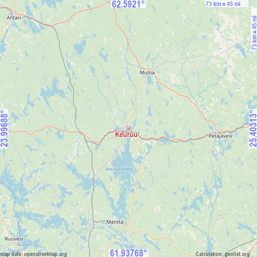
Keuruu GPS coordinates[2]
62° 16' 0.012" North, 24° 42' 0" East
| Map corner | latitude | longitude |
|---|---|---|
| Upper-left | 62.5921°, | 23.99688° |
| Center: | 62.26667°, | 24.7° |
| Lower-right: | 61.93768°, | 25.40313° |
| Map W x H: | 72.8×72.8 km | = 45.2×45.2mi |
| max Lat: | 69.90864° ⇑42.5% North |
| Keuruu: | 62.26667° |
| min Lat: | ⇓57.5% South 59.83333° |
| min Long | Keuruu | max Long |
| 21.2° | 24.7° | 30.93276° |
| W 48.9%⇐ | ⇒51.1% E |
Elevation
Elevation of Keuruu is 118 m = 387 ft, and this is 40.9 m = 134 ft above average elevation for this country.
| Max E: |
299 m = 981 ft | 19.7% |
| Keuruu | 118 m 387 ft | |
| Avg. | 77.1 m = 253 ft | |
Min E: |
1 m = 3 ft | 80.3% |
See also: Finland elevation on elevation.city.
Geographical zone
Keuruu is located in North temperate zone (between Tropic of Cancer and the Arctic Circle). Distance of this North polar circle is 477.8 km =296.9 mi to North.| Distance of | km | miles | from Keuruu |
|---|---|---|---|
| North Pole | 3083.7 | 1916.1 | to North |
| Arctic Circle | 477.8 | 296.9 | to North |
| Tropic Cancer | 4317.5 | 2682.8 | to South |
| Equator | 6923.4 | 4302 | to South |


Nearby cities:
15 places around Keuruu: (largest is in red/bold)
• Juupajoki
54.8 km =34.1 mi,  198°
198°
• Jyväskylä
52.9 km =32.9 mi,  93°
93°
• Jämsä
51.5 km =32 mi,  150°
150°
• Jämsänkoski
45.7 km =28.4 mi, 147°
• Korpilahti
52.2 km =32.4 mi,  122°
122°
• Multia
17.2 km =10.7 mi,  14°
14°
• Muurame
52.3 km =32.5 mi,  106°
106°
• Mänttä
26.6 km =16.5 mi,  188°
188°
• Petäjävesi
25.9 km =16.1 mi, 94°
• Pylkönmäki
44.8 km =27.8 mi, 6°
• Ruovesi
45.7 km =28.4 mi,  226°
226°
• Uurainen
46.6 km =29 mi,  56°
56°
• Vilppula
29.1 km =18.1 mi, 200°
• Virrat
47.7 km =29.6 mi,  267°
267°
• Ähtäri
45.8 km =28.5 mi,  314°
314°
Sources, notices
• [Note1] Compared only with cities in Finland existing in our database
• [Src1] Map data: © OpenStreetMap contributors (CC-BY-SA)
• [Src2] Other city data from geonames.org with taken over terms of usage.
• [Src3] Geographical zone / Annual Mean Temperature by Robert A. Rohde @ Wikipedia
