Leivonmäki geodata
Leivonmäki (Central Finland) is a populated place; located in Finland in Europe/Helsinki (GMT+3) time zone. With population of 1,138 people, there are 421 cities with bigger population in this country. Compared to other cities in Finland, 51.7% of cities are located further ↓South; 72.4% of cities are located further ←West and 92.1% of cities have lower elevation than Leivonmäki. Note1


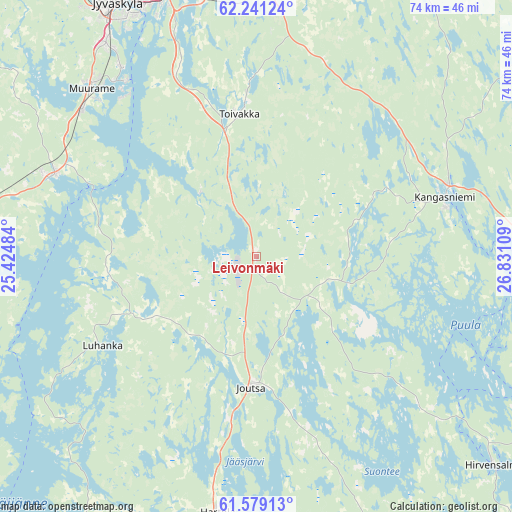
Leivonmäki GPS coordinates[2]
61° 54' 43.128" North, 26° 7' 40.656" East
| Map corner | latitude | longitude |
|---|---|---|
| Upper-left | 62.24124°, | 25.42484° |
| Center: | 61.91198°, | 26.12796° |
| Lower-right: | 61.57913°, | 26.83109° |
| Map W x H: | 73.6×73.6 km | = 45.7×45.7mi |
| max Lat: | 69.90864° ⇑48.3% North |
| Leivonmäki: | 61.91198° |
| min Lat: | ⇓51.7% South 59.83333° |
| min Long | Leivonmäki | max Long |
| 21.2° | 26.12796° | 30.93276° |
| W 72.4%⇐ | ⇒27.6% E |
Elevation
Elevation of Leivonmäki is 146 m = 479 ft, and this is 68.9 m = 226 ft above average elevation for this country.
| Max E: |
299 m = 981 ft | 7.9% |
| Leivonmäki | 146 m 479 ft | |
| Avg. | 77.1 m = 253 ft | |
Min E: |
1 m = 3 ft | 92.1% |
See also: Finland elevation on elevation.city.
Geographical zone
Leivonmäki is located in North temperate zone (between Tropic of Cancer and the Arctic Circle). Distance of this North polar circle is 517.2 km =321.4 mi to North.| Distance of | km | miles | from Leivonmäki |
|---|---|---|---|
| North Pole | 3123.1 | 1940.6 | to North |
| Arctic Circle | 517.2 | 321.4 | to North |
| Tropic Cancer | 4278 | 2658.2 | to South |
| Equator | 6884 | 4277.5 | to South |


Nearby cities:
15 places around Leivonmäki: (largest is in red/bold)
• Hankasalmi
54.8 km =34.1 mi,  16°
16°
• Hartola
37 km =23 mi,  189°
189°
• Hirvensalmi
47 km =29.2 mi,  131°
131°
• Joutsa
19.9 km =12.4 mi,  181°
181°
• Jyväskylä
42.3 km =26.3 mi,  329°
329°
• Jämsä
49.4 km =30.7 mi,  263°
263°
• Jämsänkoski
50.1 km =31.1 mi,  270°
270°
• Kangasniemi
28.7 km =17.8 mi,  71°
71°
• Korpilahti
32.4 km =20.1 mi,  291°
291°
• Luhanka
25.6 km =15.9 mi,  240°
240°
• Muurame
34.4 km =21.4 mi,  315°
315°
• Pertunmaa
49.5 km =30.8 mi,  157°
157°
• Sysmä
51.5 km =32 mi,  207°
207°
• Säynätsalo
31.5 km =19.6 mi, 323°
• Toivakka
21 km =13 mi,  353°
353°
Sources, notices
• [Note1] Compared only with cities in Finland existing in our database
• [Src1] Map data: © OpenStreetMap contributors (CC-BY-SA)
• [Src2] Other city data from geonames.org with taken over terms of usage.
• [Src3] Geographical zone / Annual Mean Temperature by Robert A. Rohde @ Wikipedia
